
寄付をします
次の冒険に備えよう:
Amazonアソシエイトとして、このサイトは対象となる購入から手数料を受け取りますが、お客様の負担はありません。
Santiago地形図
地図をクリックすると標高が表示されます。
寄付をします
次の冒険に備えよう:
Amazonアソシエイトとして、このサイトは対象となる購入から手数料を受け取りますが、お客様の負担はありません。
この地図について
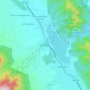
名前:Santiagoの地形図、標高、地勢。
場所:Santiago, Nuevo León, 67300, Mexico (25.38436 -100.19134 25.46436 -100.11134)
平均標高:607 m
最低標高:406 m
最大標高:1,807 m
寄付をします
次の冒険に備えよう:
Amazonアソシエイトとして、このサイトは対象となる購入から手数料を受け取りますが、お客様の負担はありません。
その他の地形図
地図をクリックすると、その地形、その標高、その地勢が表示されます。
Monterrey
The city of Monterrey is 540 metres (1,770 ft) above sea level in the northeastern state of Nuevo León. Monterrey translated from Spanish to English is "King Mount" or "King mountain", which refers to the city's topography and the large mountains that surround it. The Santa Catarina River—dry most of the…
平均標高:861 m
寄付をします
次の冒険に備えよう:
Amazonアソシエイトとして、このサイトは対象となる購入から手数料を受け取りますが、お客様の負担はありません。
National Park Summits of Monterrey
Mexico > Nuevo León > Santiago
The park is located in the northern portion of the Sierra Madre Oriental, which was formed by rock folding of marine based sedimentary strata during the Eocene epoch in the Laramide orogeny period. The marine sedimentary rock rose over the years to an elevation of 2,260 m (7,410 ft) above sea level. The…
平均標高:1,505 m
寄付をします
次の冒険に備えよう:
Amazonアソシエイトとして、このサイトは対象となる購入から手数料を受け取りますが、お客様の負担はありません。
San Pedro Garza García
On the slopes of Cerro de Chipinque, within the Cumbres de Monterrey national park, is the Chipinque Ecological Park, with 1,791 hectares, covering altitudes from 730 to 2,200 meters with representative flora and fauna. The annual average temperature is 21 °C.
平均標高:842 m
寄付をします
次の冒険に備えよう:
Amazonアソシエイトとして、このサイトは対象となる購入から手数料を受け取りますが、お客様の負担はありません。
Bustamante
Bustamante is located in an irrigated valley at the mouth of a well-watered canyon in the headwaters of the Sabinas River, a tributary of the Salado River. The Sierra de Gomas to the west of the town rise to an elevation of 5,591 feet (1,704 m) at the Cabeza de Leon four miles south-southwest of Bustamante.…
平均標高:624 m
寄付をします
次の冒険に備えよう:
Amazonアソシエイトとして、このサイトは対象となる購入から手数料を受け取りますが、お客様の負担はありません。
寄付をします
次の冒険に備えよう:
Amazonアソシエイトとして、このサイトは対象となる購入から手数料を受け取りますが、お客様の負担はありません。
San Pedro Garza García
On the slopes of Cerro de Chipinque, within the Cumbres de Monterrey national park, is the Chipinque Ecological Park, with 1,791 hectares, covering altitudes from 730 to 2,200 meters with representative flora and fauna. The annual average temperature is 21 °C.
平均標高:864 m