
寄付をします
次の冒険に備えよう:
Amazonアソシエイトとして、このサイトは対象となる購入から手数料を受け取りますが、お客様の負担はありません。
Saltillo地形図
地図をクリックすると標高が表示されます。
寄付をします
次の冒険に備えよう:
Amazonアソシエイトとして、このサイトは対象となる購入から手数料を受け取りますが、お客様の負担はありません。
Saltillo
El Cerro del Pueblo (The People's Hill) and its 4-metre (13 ft) cross overlook the city. The city's elevation makes it colder and windier than the neighboring city of Monterrey. Saltillo lies in the Chihuahuan Desert near the city of Arteaga. The city is flanked by the Zapalinamé mountains, which are part of the Sierra Madre Oriental. According to local legend, by looking at the relief of the mountains one can see the relief of Zapalinamé, chieftain of the Guachichil tribe.
寄付をします
次の冒険に備えよう:
Amazonアソシエイトとして、このサイトは対象となる購入から手数料を受け取りますが、お客様の負担はありません。
この地図について
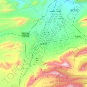
名前:Saltilloの地形図、標高、地勢。
場所:Saltillo, Coahuila, 25000, Mexico (25.26304 -101.15275 25.58304 -100.83275)
平均標高:1,857 m
最低標高:1,319 m
最大標高:3,119 m
寄付をします
次の冒険に備えよう:
Amazonアソシエイトとして、このサイトは対象となる購入から手数料を受け取りますが、お客様の負担はありません。