
寄付をします
次の冒険に備えよう:
Amazonアソシエイトとして、このサイトは対象となる購入から手数料を受け取りますが、お客様の負担はありません。
Ayodhya地形図
地図をクリックすると標高が表示されます。
寄付をします
次の冒険に備えよう:
Amazonアソシエイトとして、このサイトは対象となる購入から手数料を受け取りますが、お客様の負担はありません。
Ayodhya
The earliest of the Buddhist Pali-language texts and the Jain Prakrit-language texts mention a city called Saketa (Sageya or Saeya in Prakrit) as an important city of the Kosala mahajanapada. Topographical indications in both Buddhist and Jain texts suggest that Saketa is the same as the present-day Ayodhya. For example, according to the Samyutta Nikaya and the Vinaya Pitaka, Saketa was located at a distance of six yojanas from Shravasti. The Vinaya Pitaka mentions that a big river was located between the two cities, and the Sutta Nipata mentions Saketa as the first halting place on the southward road from Shravasti to Pratishthana.
寄付をします
次の冒険に備えよう:
Amazonアソシエイトとして、このサイトは対象となる購入から手数料を受け取りますが、お客様の負担はありません。
この地図について
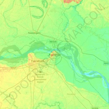
名前:Ayodhyaの地形図、標高、地勢。
場所:Ayodhya, Faizabad, Ayodhya, Uttar Pradesh, 224123, India (26.63907 82.04523 26.95907 82.36523)
平均標高:96 m
最低標高:85 m
最大標高:111 m
寄付をします
次の冒険に備えよう:
Amazonアソシエイトとして、このサイトは対象となる購入から手数料を受け取りますが、お客様の負担はありません。