
寄付をします
次の冒険に備えよう:
Amazonアソシエイトとして、このサイトは対象となる購入から手数料を受け取りますが、お客様の負担はありません。
Puerto Villamil地形図
地図をクリックすると標高が表示されます。
寄付をします
次の冒険に備えよう:
Amazonアソシエイトとして、このサイトは対象となる購入から手数料を受け取りますが、お客様の負担はありません。
この地図について
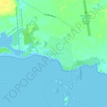
名前:Puerto Villamilの地形図、標高、地勢。
平均標高:5 m
最低標高:-1 m
最大標高:20 m
寄付をします
次の冒険に備えよう:
Amazonアソシエイトとして、このサイトは対象となる購入から手数料を受け取りますが、お客様の負担はありません。
その他の地形図
地図をクリックすると、その地形、その標高、その地勢が表示されます。
Wolf
Ecuador > Galápagos > Cantón Isabela
Wolf Island (Spanish: Isla Wolf) is a small island in the northern Galápagos Islands. It has an area of 1.3 km2 (0.5 sq mi) and a maximum altitude of 253 m (830 ft) above sea level. The island is remote from the main archipelago and has no permanent population. The Galápagos National Park does not allow…
平均標高:15 m
Roca Redonda
Ecuador > Galápagos > Cantón Isabela
Redonda Rock (Spanish: Roca Redonda, "Round Rock") is a flat-topped, steep-sided islet located roughly 25 km (16 mi) northwest of the island of Isabela in Ecuador's Galápagos Islands. Redonda measures 100 m (330 ft) long and 50 m (160 ft) wide with a maximum elevation of 67 m (220 ft). Its isolation and…
平均標高:0 m
寄付をします
次の冒険に備えよう:
Amazonアソシエイトとして、このサイトは対象となる購入から手数料を受け取りますが、お客様の負担はありません。