
寄付をします
次の冒険に備えよう:
Amazonアソシエイトとして、このサイトは対象となる購入から手数料を受け取りますが、お客様の負担はありません。
Bear Mountain地形図
地図をクリックすると標高が表示されます。
寄付をします
次の冒険に備えよう:
Amazonアソシエイトとして、このサイトは対象となる購入から手数料を受け取りますが、お客様の負担はありません。
この地図について
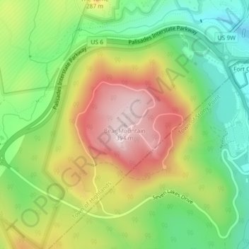
名前:Bear Mountainの地形図、標高、地勢。
平均標高:179 m
最低標高:7 m
最大標高:394 m
寄付をします
次の冒険に備えよう:
Amazonアソシエイトとして、このサイトは対象となる購入から手数料を受け取りますが、お客様の負担はありません。
その他の地形図
地図をクリックすると、その地形、その標高、その地勢が表示されます。
Salisbury Mills
United States > New York > Orange County > Town of Cornwall > Salisbury Mills
平均標高:118 m
寄付をします
次の冒険に備えよう:
Amazonアソシエイトとして、このサイトは対象となる購入から手数料を受け取りますが、お客様の負担はありません。
寄付をします
次の冒険に備えよう:
Amazonアソシエイトとして、このサイトは対象となる購入から手数料を受け取りますが、お客様の負担はありません。
Village of Maybrook
United States > New York > Orange County > Town of Montgomery
The village is mostly flat, rising up to hills on its western side. The summit of one is its highest elevation, at 520 feet (160 m) above sea level. Maybrook's lowest point is a swampy, undeveloped area in iterns northeast corner, 360 feet (110 m) in elevation.
平均標高:121 m
Town of Highlands
United States > New York > Orange County
Highlands is located at 41°21′36″N 074°00′30″W / 41.36000°N 74.00833°W / 41.36000; -74.00833 (41.3601108, -74.0084276) and its elevation is 1,017 feet (310 m). According to the 2020 U.S. census, the town has a total area of 33.46 square miles (86.66 km2), of which 30.40 square miles (78.74…
平均標高:192 m
寄付をします
次の冒険に備えよう:
Amazonアソシエイトとして、このサイトは対象となる購入から手数料を受け取りますが、お客様の負担はありません。
Town of Highlands
United States > New York > Orange County
Highlands is located at 41°21′36″N 074°00′30″W / 41.36000°N 74.00833°W / 41.36000; -74.00833 (41.3601108, -74.0084276) and its elevation is 1,017 feet (310 m). According to the 2020 U.S. census, the town has a total area of 33.46 square miles (86.66 km2), of which 30.40 square miles (78.74…
平均標高:192 m
City of Newburgh
United States > New York > Orange County
Adjacent to Newburgh, the land rises at first sharply to a bluff, where many historic structures are located, offering sweeping views of the Hudson Highlands to the south; Mount Beacon to the east and the Newburgh—Beacon Bridge to the north; then more gradually to a relatively level western half. There are…
平均標高:32 m
寄付をします
次の冒険に備えよう:
Amazonアソシエイトとして、このサイトは対象となる購入から手数料を受け取りますが、お客様の負担はありません。
寄付をします
次の冒険に備えよう:
Amazonアソシエイトとして、このサイトは対象となる購入から手数料を受け取りますが、お客様の負担はありません。
寄付をします
次の冒険に備えよう:
Amazonアソシエイトとして、このサイトは対象となる購入から手数料を受け取りますが、お客様の負担はありません。
Town of Montgomery
United States > New York > Orange County
The town's topography is generally level and low, except along parts of its eastern and western boundaries, reflecting the passage of the Wallkill River through it from north to west. There are large swamps in the south portion of town, some of them draining into the Otter Kill. Further north, the land becomes…
平均標高:128 m
寄付をします
次の冒険に備えよう:
Amazonアソシエイトとして、このサイトは対象となる購入から手数料を受け取りますが、お客様の負担はありません。
寄付をします
次の冒険に備えよう:
Amazonアソシエイトとして、このサイトは対象となる購入から手数料を受け取りますが、お客様の負担はありません。
Town of Cornwall
United States > New York > Orange County
This area of town is also mountainous and rugged, with the border descending along a northwesterly line to the narrow Woodbury Creek valley, where NY 32 and the New York State Thruway enter the town. At the valley's mouth, where Woodbury Creek drains into Moodna Creek, is the small hamlet of Mountainville,…
平均標高:182 m
Village of Maybrook
United States > New York > Orange County > Town of Montgomery
The village is mostly flat, rising up to hills on its western side. The summit of one is its highest elevation, at 520 feet (160 m) above sea level. Maybrook's lowest point is a swampy, undeveloped area in iterns northeast corner, 360 feet (110 m) in elevation.
平均標高:121 m
寄付をします
次の冒険に備えよう:
Amazonアソシエイトとして、このサイトは対象となる購入から手数料を受け取りますが、お客様の負担はありません。
寄付をします
次の冒険に備えよう:
Amazonアソシエイトとして、このサイトは対象となる購入から手数料を受け取りますが、お客様の負担はありません。
寄付をします
次の冒険に備えよう:
Amazonアソシエイトとして、このサイトは対象となる購入から手数料を受け取りますが、お客様の負担はありません。
Village of Walden
United States > New York > Orange County
The Wallkill passes through a small gorge between the two dams and loses approximately 60 feet (18 m) of elevation in the process. The surrounding topography in the village is, correspondingly, gentle rolling hills of this section of the Great Appalachian Valley between the higher rises of the Shawangunk…
平均標高:114 m
寄付をします
次の冒険に備えよう:
Amazonアソシエイトとして、このサイトは対象となる購入から手数料を受け取りますが、お客様の負担はありません。
寄付をします
次の冒険に備えよう:
Amazonアソシエイトとして、このサイトは対象となる購入から手数料を受け取りますが、お客様の負担はありません。
Village of Walden
United States > New York > Orange County
The Wallkill passes through a small gorge between the two dams and loses approximately 60 feet (18 m) of elevation in the process. The surrounding topography in the village is, correspondingly, gentle rolling hills of this section of the Great Appalachian Valley between the higher rises of the Shawangunk…
平均標高:114 m
寄付をします
次の冒険に備えよう:
Amazonアソシエイトとして、このサイトは対象となる購入から手数料を受け取りますが、お客様の負担はありません。
Montgomery
United States > New York > Orange County > Montgomery
These lands in the west are the lowest-lying in the village. Much of its topography rises gently from the river, with little relief save the Academy Hill area on the east edge of downtown where the village hall is located, and a 455-foot (139 m) hill at the junction of Purple Martin Road and Cardinal Drive…
平均標高:118 m
寄付をします
次の冒険に備えよう:
Amazonアソシエイトとして、このサイトは対象となる購入から手数料を受け取りますが、お客様の負担はありません。
Town of Montgomery
United States > New York > Orange County
The town's topography is generally level and low, except along parts of its eastern and western boundaries, reflecting the passage of the Wallkill River through it from north to west. There are large swamps in the south portion of town, some of them draining into the Otter Kill. Further north, the land becomes…
平均標高:128 m
寄付をします
次の冒険に備えよう:
Amazonアソシエイトとして、このサイトは対象となる購入から手数料を受け取りますが、お客様の負担はありません。