
寄付をします
次の冒険に備えよう:
Amazonアソシエイトとして、このサイトは対象となる購入から手数料を受け取りますが、お客様の負担はありません。
Sehore地形図
地図をクリックすると標高が表示されます。
寄付をします
次の冒険に備えよう:
Amazonアソシエイトとして、このサイトは対象となる購入から手数料を受け取りますが、お客様の負担はありません。
Sehore
Sehore is 37 km from the state capital, Bhopal, towards the south-west and on the Bhopal - Indore highway. Its height from mean sea level is between 1500 ft. and 2000 ft. Sehore is situated on the Western Railway line from Bhopal to Ratlam. It is surrounded by 7 districts: Bhopal, Raisen, Harda, Hoshangabad, Dewas, Shajapur and Rajgarh. Sehore district extends between the parallels of Latitude 22'31 to 23'40 North and between the meridians of Longitude 76'22 and 78'08 East. Sehore is located at 23°12′N 77°05′E / 23.2°N 77.08°E / 23.2; 77.08. It has an average elevation of 502 metres (1646 feet). The only river passing through the Sehore district is the Siven.
寄付をします
次の冒険に備えよう:
Amazonアソシエイトとして、このサイトは対象となる購入から手数料を受け取りますが、お客様の負担はありません。
この地図について
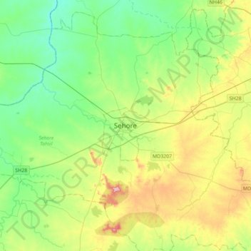
名前:Sehoreの地形図、標高、地勢。
平均標高:501 m
最低標高:449 m
最大標高:611 m
寄付をします
次の冒険に備えよう:
Amazonアソシエイトとして、このサイトは対象となる購入から手数料を受け取りますが、お客様の負担はありません。