
寄付をします
次の冒険に備えよう:
Amazonアソシエイトとして、このサイトは対象となる購入から手数料を受け取りますが、お客様の負担はありません。
Stirling地形図
地図をクリックすると標高が表示されます。
寄付をします
次の冒険に備えよう:
Amazonアソシエイトとして、このサイトは対象となる購入から手数料を受け取りますが、お客様の負担はありません。
この地図について
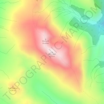
名前:Stirlingの地形図、標高、地勢。
場所:Stirling, Scotland, FK17 8HR, United Kingdom, Ben Ledi (56.25856 -4.32217 56.25866 -4.32207)
平均標高:544 m
最低標高:217 m
最大標高:872 m
寄付をします
次の冒険に備えよう:
Amazonアソシエイトとして、このサイトは対象となる購入から手数料を受け取りますが、お客様の負担はありません。
その他の地形図
地図をクリックすると、その地形、その標高、その地勢が表示されます。
Out Skerries
United Kingdom > Scotland > Shetland
Being so close to Norway, the islands were of strategic importance in World War II and were a regular landfall for Norwegian boats carrying escapees from the Nazi occupation. The local coastguard were responsible for the refugees and at one point during the war were issued with a tommy gun, although initially…
平均標高:1 m
Eilean Donan
United Kingdom > Scotland > Highland > Dornie > Totaig
In 1689, King James VII of the House of Stuart was declared to have to forfeit the throne, and the crown was offered to William of Orange, in the so-called "Glorious Revolution". The revolution also established Presbyterianism in Scotland, although the Highlands generally remained Roman Catholic and loyal to…
平均標高:82 m
寄付をします
次の冒険に備えよう:
Amazonアソシエイトとして、このサイトは対象となる購入から手数料を受け取りますが、お客様の負担はありません。
寄付をします
次の冒険に備えよう:
Amazonアソシエイトとして、このサイトは対象となる購入から手数料を受け取りますが、お客様の負担はありません。
Ailsa Craig
In a small glen above Ailsa Castle, a small freshwater body known as the Garry Loch is located at an altitude of 247 m (810 ft), with a depth of at least 17 feet.
平均標高:14 m
寄付をします
次の冒険に備えよう:
Amazonアソシエイトとして、このサイトは対象となる購入から手数料を受け取りますが、お客様の負担はありません。
寄付をします
次の冒険に備えよう:
Amazonアソシエイトとして、このサイトは対象となる購入から手数料を受け取りますが、お客様の負担はありません。
Àird
United Kingdom > Scotland > Western Isles
There is a dense cluster of lochs across almost the entire island, and almost all of the island is below 20 metres (70 feet) in elevation.
平均標高:5 m
寄付をします
次の冒険に備えよう:
Amazonアソシエイトとして、このサイトは対象となる購入から手数料を受け取りますが、お客様の負担はありません。
寄付をします
次の冒険に備えよう:
Amazonアソシエイトとして、このサイトは対象となる購入から手数料を受け取りますが、お客様の負担はありません。
Lerwick
United Kingdom > Scotland > Shetland
Lerwick has transitioned from a subpolar oceanic climate (Cfc) to a maritime climate (Cfb) with cool to cold temperatures all year long. The lack of trees reflects the latter type. This is particularly pronounced by virtue of Lerwick being on the coast of an island, so even extreme temperature records are…
平均標高:34 m
寄付をします
次の冒険に備えよう:
Amazonアソシエイトとして、このサイトは対象となる購入から手数料を受け取りますが、お客様の負担はありません。
寄付をします
次の冒険に備えよう:
Amazonアソシエイトとして、このサイトは対象となる購入から手数料を受け取りますが、お客様の負担はありません。
寄付をします
次の冒険に備えよう:
Amazonアソシエイトとして、このサイトは対象となる購入から手数料を受け取りますが、お客様の負担はありません。
寄付をします
次の冒険に備えよう:
Amazonアソシエイトとして、このサイトは対象となる購入から手数料を受け取りますが、お客様の負担はありません。
East Ayrshire
East Ayrshire is located on the west coat of Scotland, sharing borders with the following neighbouring council areas; North Ayrshire, South Ayrshire, Dumfries and Galloway, East Renfrewshire and South Lanarkshire. Blackcraig Hill reaches an elevation of 2,298 feet (700 metres), the highest peak in East…
平均標高:225 m
寄付をします
次の冒険に備えよう:
Amazonアソシエイトとして、このサイトは対象となる購入から手数料を受け取りますが、お客様の負担はありません。