
寄付をします
次の冒険に備えよう:
Amazonアソシエイトとして、このサイトは対象となる購入から手数料を受け取りますが、お客様の負担はありません。
Telagabodas地形図
地図をクリックすると標高が表示されます。
寄付をします
次の冒険に備えよう:
Amazonアソシエイトとして、このサイトは対象となる購入から手数料を受け取りますが、お客様の負担はありません。
Telagabodas
Mount Talagabodas or Mount Telagabodas (which means Mount of White Lake (refer to white crater lake) in Sundanese) is a stratovolcano in West Java, Indonesia. The volcano is about 25 km to the east of the town of Garut and is built up of andesitic lavas and pyroclastics. Fumaroles, mud pots and hot springs are found around the crater lake. Changes of the lake color occurred in 1913 and 1921. The diameter of crater lake is less than 2 km and lies at an altitude of 1,720 m or 1,020 m above Garut plains.
寄付をします
次の冒険に備えよう:
Amazonアソシエイトとして、このサイトは対象となる購入から手数料を受け取りますが、お客様の負担はありません。
この地図について
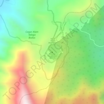
名前:Telagabodasの地形図、標高、地勢。
場所:Telagabodas, Garut, West Java, Java, Indonesia (-7.21086 108.06489 -7.21076 108.06499)
平均標高:1,735 m
最低標高:1,398 m
最大標高:2,149 m
寄付をします
次の冒険に備えよう:
Amazonアソシエイトとして、このサイトは対象となる購入から手数料を受け取りますが、お客様の負担はありません。