
寄付をします
次の冒険に備えよう:
Amazonアソシエイトとして、このサイトは対象となる購入から手数料を受け取りますが、お客様の負担はありません。
Thengapattinam地形図
地図をクリックすると標高が表示されます。
寄付をします
次の冒険に備えよう:
Amazonアソシエイトとして、このサイトは対象となる購入から手数料を受け取りますが、お客様の負担はありません。
Thengapattinam
Thengapattanam is located in the South western coast of India bordering the Arabian Sea to the west, western ghats to the north, and vast fertile plains with intermittent Rocky hills to the east. The town is 11 km into the Tamil Nadu border from Kerala. The Kerala state capital Thiruvananthapuram is 45 km away from here, whereas Nagercoil is 35 km away. It shares borders with Erayumanthurai, and Amsi villages on either side. The mean elevation of the town is 9 ft (2.7 m) with the highest point Chentapalli Rock being 50 ft (15 m) high above sea level. The Thamirabarani River wraps around most parts of the Kanyakumari district and becomes Kuzhithurai River before reaching Thengapattanam Estuary.
寄付をします
次の冒険に備えよう:
Amazonアソシエイトとして、このサイトは対象となる購入から手数料を受け取りますが、お客様の負担はありません。
この地図について
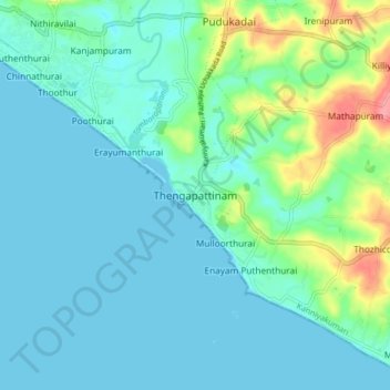
名前:Thengapattinamの地形図、標高、地勢。
平均標高:17 m
最低標高:-1 m
最大標高:86 m
寄付をします
次の冒険に備えよう:
Amazonアソシエイトとして、このサイトは対象となる購入から手数料を受け取りますが、お客様の負担はありません。