
寄付をします
次の冒険に備えよう:
Amazonアソシエイトとして、このサイトは対象となる購入から手数料を受け取りますが、お客様の負担はありません。
Tlaxcala City地形図
地図をクリックすると標高が表示されます。
寄付をします
次の冒険に備えよう:
Amazonアソシエイトとして、このサイトは対象となる購入から手数料を受け取りますが、お客様の負担はありません。
Tlaxcala City
The city is located in the central Mexican highlands 2,239 metres (7,346 feet) above sea level, in a valley of the same name, from which the Popocatépetl and Iztaccíhuatl volcanoes can be seen in the distance. The main elevations in the municipality are El Cerro Ostol at 2,460 metres (8,070 feet) and El Cerro Tepepan at 2,320 metres (7,610 feet).
寄付をします
次の冒険に備えよう:
Amazonアソシエイトとして、このサイトは対象となる購入から手数料を受け取りますが、お客様の負担はありません。
この地図について
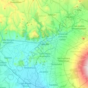
名前:Tlaxcala Cityの地形図、標高、地勢。
平均標高:2,414 m
最低標高:2,178 m
最大標高:3,267 m
寄付をします
次の冒険に備えよう:
Amazonアソシエイトとして、このサイトは対象となる購入から手数料を受け取りますが、お客様の負担はありません。
その他の地形図
地図をクリックすると、その地形、その標高、その地勢が表示されます。
Tlaxcala de Xicohténcatl
Mexico > Tlaxcala > Municipio de Tlaxcala
The city is located in the central Mexican highlands 2,239 metres (7,346 feet) above sea level, in a valley of the same name, from which the Popocatépetl and Iztaccíhuatl volcanoes can be seen in the distance. The main elevations in the municipality are El Cerro Ostol at 2,460 metres (8,070 feet) and El…
平均標高:2,268 m