
寄付をします
次の冒険に備えよう:
Amazonアソシエイトとして、このサイトは対象となる購入から手数料を受け取りますが、お客様の負担はありません。
Dale地形図
地図をクリックすると標高が表示されます。
寄付をします
次の冒険に備えよう:
Amazonアソシエイトとして、このサイトは対象となる購入から手数料を受け取りますが、お客様の負担はありません。
この地図について
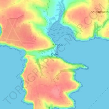
名前:Daleの地形図、標高、地勢。
場所:Dale, Pembrokeshire, Wales, SA62 3RB, United Kingdom (51.68752 -5.18944 51.72752 -5.14944)
平均標高:27 m
最低標高:-1 m
最大標高:71 m
寄付をします
次の冒険に備えよう:
Amazonアソシエイトとして、このサイトは対象となる購入から手数料を受け取りますが、お客様の負担はありません。
その他の地形図
地図をクリックすると、その地形、その標高、その地勢が表示されます。
Caldey Island
United Kingdom > Wales > Pembrokeshire
Caldey Island is about 1.5 miles (2.4 km) long and 1 mile (1.6 km) in width at its widest. It has an area of 538 acres (2.18 km2) and its highest elevation is 197 feet (60 m). The island lies in Carmarthen Bay on the northern side of the Bristol Channel in the county of Pembrokeshire, a little over 2.5 miles…
平均標高:5 m
寄付をします
次の冒険に備えよう:
Amazonアソシエイトとして、このサイトは対象となる購入から手数料を受け取りますが、お客様の負担はありません。
Milford Haven
United Kingdom > Wales > Pembrokeshire
One of the earliest notable figures from the Milford Haven area is Howell Davis, a pirate born in 1680. He was shot dead in 1719 on the Portuguese island of Príncipe. Other famous residents connected as seafarers include Isaac Davis, a former seaman who was engaged in the fur trade between the Pacific…
平均標高:36 m