
寄付をします
次の冒険に備えよう:
Amazonアソシエイトとして、このサイトは対象となる購入から手数料を受け取りますが、お客様の負担はありません。
Auburn地形図
地図をクリックすると標高が表示されます。
寄付をします
次の冒険に備えよう:
Amazonアソシエイトとして、このサイトは対象となる購入から手数料を受け取りますが、お客様の負担はありません。
Auburn
The southwest and west regions of the city on the plateau are marked by rolling plains and savannahs, with the undeveloped portion primarily being used for cattle grazing and ranching. South of this region sits the coastal plain, with sandy soil and pine forest. Parts of north Auburn have much more rugged topographies, with thick forests in high hills and deep hollows of the type common to parts of eastern Tennessee. The region surrounded by Chewacla Park in the south of the city contains sharp peaks and sudden drops of elevation as the 1.05 billion-year-old rock of the Appalachians meets the coastal plain.
寄付をします
次の冒険に備えよう:
Amazonアソシエイトとして、このサイトは対象となる購入から手数料を受け取りますが、お客様の負担はありません。
この地図について
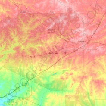
名前:Auburnの地形図、標高、地勢。
場所:Auburn, Lee County, Alabama, 36949, United States (32.44986 -85.64078 32.76986 -85.32078)
平均標高:189 m
最低標高:78 m
最大標高:270 m
寄付をします
次の冒険に備えよう:
Amazonアソシエイトとして、このサイトは対象となる購入から手数料を受け取りますが、お客様の負担はありません。