
寄付をします
次の冒険に備えよう:
Amazonアソシエイトとして、このサイトは対象となる購入から手数料を受け取りますが、お客様の負担はありません。
Hercules地形図
地図をクリックすると標高が表示されます。
寄付をします
次の冒険に備えよう:
Amazonアソシエイトとして、このサイトは対象となる購入から手数料を受け取りますが、お客様の負担はありません。
この地図について
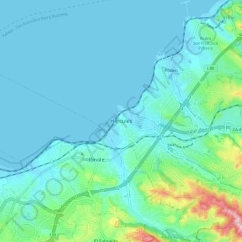
名前:Herculesの地形図、標高、地勢。
平均標高:35 m
最低標高:-2 m
最大標高:234 m
寄付をします
次の冒険に備えよう:
Amazonアソシエイトとして、このサイトは対象となる購入から手数料を受け取りますが、お客様の負担はありません。
その他の地形図
地図をクリックすると、その地形、その標高、その地勢が表示されます。
El Cerrito
United States > California > Contra Costa County
According to the United States Census Bureau, the city has a total area of 3.7 square miles (9.6 km2), all of it land. The city ranges in elevation from 20 to 934 feet, with an average elevation of 69 feet (21 m).
平均標高:91 m
Walnut Creek
United States > California > Contra Costa County
Walnut Creek's warm summer Mediterranean climate (Köppen climate classification Csb) is typical of California's interior valleys. In summer, high pressure results in almost unbroken sunshine and virtually no precipitation. Days start out cool but quickly warm up, with high temperatures normally in the 80s…
平均標高:119 m
寄付をします
次の冒険に備えよう:
Amazonアソシエイトとして、このサイトは対象となる購入から手数料を受け取りますが、お客様の負担はありません。
Orinda
United States > California > Contra Costa County
The area is characterized by a warm-summer Mediterranean climate (Köppen climate classification Csb) with cool, rainy winters and warm, dry summers. Because Orinda is located in a hilly area, microclimates often dominate temperature differences in short distances. The Oakland Hills often block the cool foggy…
平均標高:246 m
寄付をします
次の冒険に備えよう:
Amazonアソシエイトとして、このサイトは対象となる購入から手数料を受け取りますが、お客様の負担はありません。
San Ramon
United States > California > Contra Costa County
The topography of San Ramon is varied, featuring a mix of the rolling hills of the Diablo Range and the flatter basin of the San Ramon Valley. The city is predominantly urban and residential with many new housing developments; however, much of the land around the city's perimeter regions remains undeveloped,…
平均標高:210 m
寄付をします
次の冒険に備えよう:
Amazonアソシエイトとして、このサイトは対象となる購入から手数料を受け取りますが、お客様の負担はありません。
寄付をします
次の冒険に備えよう:
Amazonアソシエイトとして、このサイトは対象となる購入から手数料を受け取りますが、お客様の負担はありません。
寄付をします
次の冒険に備えよう:
Amazonアソシエイトとして、このサイトは対象となる購入から手数料を受け取りますが、お客様の負担はありません。
寄付をします
次の冒険に備えよう:
Amazonアソシエイトとして、このサイトは対象となる購入から手数料を受け取りますが、お客様の負担はありません。
El Cerrito
United States > California > Contra Costa County
According to the United States Census Bureau, the city has a total area of 3.7 square miles (9.6 km2), all of it land. The city ranges in elevation from 20 to 934 feet, with an average elevation of 69 feet (21 m).
平均標高:91 m
Moraga
United States > California > Contra Costa County
Moraga is located at 37°50'06" North, 122°07'47" West, at an elevation of 499 feet (152 m). It is located adjacent to the cities of Lafayette and Orinda, as well as the unincorporated community of Canyon. Other nearby cities include Walnut Creek, Oakland, San Francisco, Concord and Berkeley.
平均標高:224 m
寄付をします
次の冒険に備えよう:
Amazonアソシエイトとして、このサイトは対象となる購入から手数料を受け取りますが、お客様の負担はありません。
Walnut Creek
United States > California > Contra Costa County
Walnut Creek's warm summer Mediterranean climate (Köppen climate classification Csb) is typical of California's interior valleys. In summer, high pressure results in almost unbroken sunshine and virtually no precipitation. Days start out cool but quickly warm up, with high temperatures normally in the 80s…
平均標高:119 m
Mount Diablo State Park
United States > California > Contra Costa County > Clayton
Mount Diablo is a mountain of the Diablo Range, in Contra Costa County of the eastern San Francisco Bay Area in Northern California. It is south of Clayton and northeast of Danville. It is an isolated upthrust peak of 3,849 feet (1,173 meters), visible from most of the San Francisco Bay Area. Mount Diablo…
平均標高:334 m
寄付をします
次の冒険に備えよう:
Amazonアソシエイトとして、このサイトは対象となる購入から手数料を受け取りますが、お客様の負担はありません。
寄付をします
次の冒険に備えよう:
Amazonアソシエイトとして、このサイトは対象となる購入から手数料を受け取りますが、お客様の負担はありません。
寄付をします
次の冒険に備えよう:
Amazonアソシエイトとして、このサイトは対象となる購入から手数料を受け取りますが、お客様の負担はありません。
寄付をします
次の冒険に備えよう:
Amazonアソシエイトとして、このサイトは対象となる購入から手数料を受け取りますが、お客様の負担はありません。
寄付をします
次の冒険に備えよう:
Amazonアソシエイトとして、このサイトは対象となる購入から手数料を受け取りますが、お客様の負担はありません。
寄付をします
次の冒険に備えよう:
Amazonアソシエイトとして、このサイトは対象となる購入から手数料を受け取りますが、お客様の負担はありません。
San Ramon
United States > California > Contra Costa County
The topography of San Ramon is varied, featuring a mix of the rolling hills of the Diablo Range and the flatter basin of the San Ramon Valley. The city is predominantly urban and residential with many new housing developments; however, much of the land around the city's perimeter regions remains undeveloped,…
平均標高:210 m
寄付をします
次の冒険に備えよう:
Amazonアソシエイトとして、このサイトは対象となる購入から手数料を受け取りますが、お客様の負担はありません。
寄付をします
次の冒険に備えよう:
Amazonアソシエイトとして、このサイトは対象となる購入から手数料を受け取りますが、お客様の負担はありません。
Orinda
United States > California > Contra Costa County
The area is characterized by a warm-summer Mediterranean climate (Köppen climate classification: Csb) with cool, rainy winters and warm, dry summers. Because Orinda is located in a hilly area, microclimates often dominate temperature differences in short distances. The Oakland Hills often block the cool foggy…
平均標高:246 m
寄付をします
次の冒険に備えよう:
Amazonアソシエイトとして、このサイトは対象となる購入から手数料を受け取りますが、お客様の負担はありません。