

寄付をします
次の冒険に備えよう:
Amazonアソシエイトとして、このサイトは対象となる購入から手数料を受け取りますが、お客様の負担はありません。
Paris地形図
地図をクリックすると標高が表示されます。
寄付をします
次の冒険に備えよう:
Amazonアソシエイトとして、このサイトは対象となる購入から手数料を受け取りますが、お客様の負担はありません。
Paris
Paris in its early history had only the rivers Seine and Bièvre for water. From 1809, the Canal de l'Ourcq provided Paris with water from less-polluted rivers to the north-east of the capital. From 1857, the civil engineer Eugène Belgrand, under Napoleon III, oversaw the construction of a series of new aqueducts that brought water from locations all around the city to several reservoirs built atop the Capital's highest points of elevation. From then on, the new reservoir system became Paris' principal source of drinking water, and the remains of the old system, pumped into lower levels of the same reservoirs, were from then on used for the cleaning of Paris' streets. This system is still a major part of Paris' modern water-supply network. Today Paris has more than 2,400 km (1,491 mi) of underground passageways dedicated to the evacuation of Paris' liquid wastes.
寄付をします
次の冒険に備えよう:
Amazonアソシエイトとして、このサイトは対象となる購入から手数料を受け取りますが、お客様の負担はありません。
この地図について
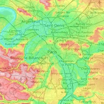
名前:Parisの地形図、標高、地勢。
場所:Paris, Metropolitan France, 75044, France (48.69670 2.19146 49.01670 2.51146)
平均標高:75 m
最低標高:19 m
最大標高:190 m
寄付をします
次の冒険に備えよう:
Amazonアソシエイトとして、このサイトは対象となる購入から手数料を受け取りますが、お客様の負担はありません。