
寄付をします
次の冒険に備えよう:
Amazonアソシエイトとして、このサイトは対象となる購入から手数料を受け取りますが、お客様の負担はありません。
Middle Neck地形図
地図をクリックすると標高が表示されます。
寄付をします
次の冒険に備えよう:
Amazonアソシエイトとして、このサイトは対象となる購入から手数料を受け取りますが、お客様の負担はありません。
この地図について
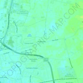
名前:Middle Neckの地形図、標高、地勢。
場所:Middle Neck, Wicomico County, Maryland, 21875, United States (38.37901 -75.56742 38.41901 -75.52742)
平均標高:15 m
最低標高:10 m
最大標高:21 m
寄付をします
次の冒険に備えよう:
Amazonアソシエイトとして、このサイトは対象となる購入から手数料を受け取りますが、お客様の負担はありません。
その他の地形図
地図をクリックすると、その地形、その標高、その地勢が表示されます。
寄付をします
次の冒険に備えよう:
Amazonアソシエイトとして、このサイトは対象となる購入から手数料を受け取りますが、お客様の負担はありません。
Salisbury
United States > Maryland > Wicomico County
According to the United States Census Bureau, the city has a total area of 13.87 square miles (35.92 km2), of which 13.40 square miles (34.71 km2) is land and 0.47 square miles (1.22 km2) is water. The city has a varying elevation of 17 to 45 feet (5.2 to 13.7 m) above sea level.
平均標高:12 m