
寄付をします
次の冒険に備えよう:
Amazonアソシエイトとして、このサイトは対象となる購入から手数料を受け取りますが、お客様の負担はありません。
Sugar Valley地形図
地図をクリックすると標高が表示されます。
寄付をします
次の冒険に備えよう:
Amazonアソシエイトとして、このサイトは対象となる購入から手数料を受け取りますが、お客様の負担はありません。
この地図について
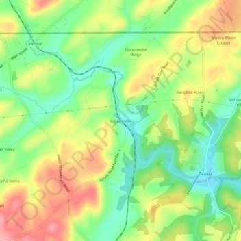
名前:Sugar Valleyの地形図、標高、地勢。
場所:Sugar Valley, Carroll County, Maryland, 21102, United States (39.68588 -76.84520 39.72588 -76.80520)
平均標高:236 m
最低標高:180 m
最大標高:304 m
寄付をします
次の冒険に備えよう:
Amazonアソシエイトとして、このサイトは対象となる購入から手数料を受け取りますが、お客様の負担はありません。
その他の地形図
地図をクリックすると、その地形、その標高、その地勢が表示されます。
Mount Airy
United States > Maryland > Carroll County
The town was originally settled in the early 1830s by a core group of six families. Dorsey, Davis and Bussard were the most prominent names in that first settlement, which was followed closely by the construction of the B & O railroad line in 1831. Because Mount Airy sits at an elevation of 830 feet (250 m), a…
平均標高:221 m
Westminster
United States > Maryland > Carroll County
Westminster lies in the humid subtropical climate zone, with hot and humid summers and cool winters with highly variable seasonal snowfall. Due to its elevation, distance from the Chesapeake Bay and urban heat island, temperatures in Westminster are often considerably lower than in Baltimore, especially at…
平均標高:226 m
寄付をします
次の冒険に備えよう:
Amazonアソシエイトとして、このサイトは対象となる購入から手数料を受け取りますが、お客様の負担はありません。
寄付をします
次の冒険に備えよう:
Amazonアソシエイトとして、このサイトは対象となる購入から手数料を受け取りますが、お客様の負担はありません。
Mount Airy
United States > Maryland > Carroll County
The town was originally settled in the early 1830s by a core group of six families. Dorsey, Davis and Bussard were the most prominent names in that first settlement, which was followed closely by the construction of the B & O railroad line in 1831. Because Mount Airy sits at an elevation of 830 feet (250 m), a…
平均標高:221 m
寄付をします
次の冒険に備えよう:
Amazonアソシエイトとして、このサイトは対象となる購入から手数料を受け取りますが、お客様の負担はありません。
Westminster
United States > Maryland > Carroll County
Westminster lies in the humid subtropical climate zone bordering on a humid continental climate, with hot and humid summers and cool winters with highly variable seasonal snowfall. Due to its elevation, distance from the Chesapeake Bay and urban heat island, temperatures in Westminster are often considerably…
平均標高:228 m