
寄付をします
次の冒険に備えよう:
Amazonアソシエイトとして、このサイトは対象となる購入から手数料を受け取りますが、お客様の負担はありません。
Nicasio地形図
地図をクリックすると標高が表示されます。
寄付をします
次の冒険に備えよう:
Amazonアソシエイトとして、このサイトは対象となる購入から手数料を受け取りますが、お客様の負担はありません。
この地図について
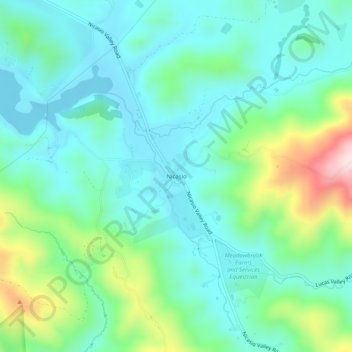
名前:Nicasioの地形図、標高、地勢。
場所:Nicasio, Marin County, California, 94946, United States (38.04159 -122.71860 38.08159 -122.67860)
平均標高:137 m
最低標高:44 m
最大標高:428 m
寄付をします
次の冒険に備えよう:
Amazonアソシエイトとして、このサイトは対象となる購入から手数料を受け取りますが、お客様の負担はありません。
その他の地形図
地図をクリックすると、その地形、その標高、その地勢が表示されます。
San Rafael
United States > California > Marin County
San Rafael has a wide diversity of natural habitats from forests at the higher elevations to marshland and estuarine settings. Its marshes are home to the endangered species salt marsh harvest mouse. There are also riparian areas including the San Rafael Creek and Miller Creek corridors.
平均標高:78 m
寄付をします
次の冒険に備えよう:
Amazonアソシエイトとして、このサイトは対象となる購入から手数料を受け取りますが、お客様の負担はありません。
Bel Marin Keys
United States > California > Marin County
Bel Marin Keys is an unincorporated community in Marin County, California. It lies at an elevation of 10 feet (3.0 m).
平均標高:4 m
寄付をします
次の冒険に備えよう:
Amazonアソシエイトとして、このサイトは対象となる購入から手数料を受け取りますが、お客様の負担はありません。
Bolinas
United States > California > Marin County
Bolinas sits at an elevation of 36 feet (11 m) above sea level. It is bound on the northeast by Bolinas Lagoon and Kent Island, on the south by Bolinas Bay and Duxbury Point, on the southwest by the Pacific Ocean, and on the northwest by Point Reyes National Seashore. According to the United States Census…
平均標高:28 m
寄付をします
次の冒険に備えよう:
Amazonアソシエイトとして、このサイトは対象となる購入から手数料を受け取りますが、お客様の負担はありません。
Point Reyes Station
United States > California > Marin County
Point Reyes Station (formerly Marin and Olema Station) is a small unincorporated town in western Marin County, California, United States. Point Reyes Station is located 13 miles (21 km) south-southeast of Tomales, at an elevation of 39 feet (12 m). Point Reyes Station is located along State Route 1 and is a…
平均標高:66 m
寄付をします
次の冒険に備えよう:
Amazonアソシエイトとして、このサイトは対象となる購入から手数料を受け取りますが、お客様の負担はありません。
San Rafael
United States > California > Marin County
San Rafael has a wide diversity of natural habitats from forests at the higher elevations to marshland and estuarine settings. Its marshes are home to the endangered species salt marsh harvest mouse. There are also riparian areas including the San Rafael Creek and Miller Creek corridors.
平均標高:79 m
Fairfax
United States > California > Marin County
Fairfax is an incorporated town in Marin County, California, United States. Fairfax is located 3.25 miles (5.2 km) west-northwest of San Rafael, at an elevation of 115 feet (35 m). The population was 7,605 at the 2020 census.
平均標高:97 m
Fairfax
United States > California > Marin County
Fairfax is an incorporated town in Marin County, California, United States. Fairfax is located 3.25 miles (5.2 km) west-northwest of San Rafael, at an elevation of 115 feet (35 m). The population was 7,605 at the 2020 census.
平均標高:97 m
寄付をします
次の冒険に備えよう:
Amazonアソシエイトとして、このサイトは対象となる購入から手数料を受け取りますが、お客様の負担はありません。
Corte Madera
United States > California > Marin County
Corte Madera (/ˈkɔːrtə məˈdɛrə/; Spanish for "Chop Wood") is an incorporated town in Marin County, California. Corte Madera is located 3.25 miles (5.2 km) south of San Rafael, at an elevation of 39 feet (12 m). The population was 10,222 at the 2020 census. The town was named after the Spanish…
平均標高:52 m
San Geronimo
United States > California > Marin County
San Geronimo (Spanish: San Gerónimo, meaning "St. Jerome") is a census-designated place (CDP) located in the San Geronimo Valley in Marin County, California in the United States. San Geronimo is bordered by Lagunitas-Forest Knolls to its west and Woodacre to its east. It is 8 miles (13 km) southwest of…
平均標高:234 m
寄付をします
次の冒険に備えよう:
Amazonアソシエイトとして、このサイトは対象となる購入から手数料を受け取りますが、お客様の負担はありません。
Ross
United States > California > Marin County
Ross is a small incorporated town in Marin County, California, United States, just north of San Francisco. Ross is located 1.5 miles (2.4 km) west-southwest of San Rafael, at an elevation of 36 feet (11 m). The population was 2,338 at the 2020 census. The town is bordered by San Rafael to the east, Kentfield…
平均標高:49 m
Stinson Beach
United States > California > Marin County
Stinson Beach is an unincorporated community and census-designated place (CDP) in Marin County, California, on the west coast of the United States. Stinson Beach is located east-southeast of Bolinas, right across the channel that terminates the bay mouth bar of the Bolinas Lagoon. at an elevation of 26 feet (8…
平均標高:155 m
寄付をします
次の冒険に備えよう:
Amazonアソシエイトとして、このサイトは対象となる購入から手数料を受け取りますが、お客様の負担はありません。
Kentfield
United States > California > Marin County > Kentfield
Kentfield (formerly Ross Landing, Tamalpais, and Kent) is a census-designated place (CDP) in Marin County, California, United States, just north of San Francisco. Kentfield is located 2 miles (3 km) southwest of downtown San Rafael, at an elevation of 115 feet (35 m). The population was 6,808 at the 2020…
平均標高:151 m
寄付をします
次の冒険に備えよう:
Amazonアソシエイトとして、このサイトは対象となる購入から手数料を受け取りますが、お客様の負担はありません。
San Anselmo
United States > California > Marin County
San Anselmo (Spanish for "Saint Anselm") is an incorporated town in Marin County, California, United States. San Anselmo is located 1.5 miles (2.4 km) west of San Rafael, at an elevation of 46 feet (14 m). It is located about 20 miles (32 km) north of San Francisco. The town is bordered by San Rafael to the…
平均標高:66 m
Woodacre
United States > California > Marin County
The community is located at 38°00′46″N 122°38′43″W / 38.01278°N 122.64528°W / 38.01278; -122.64528 in the eastern half of the San Geronimo Valley of central Marin County. San Geronimo and Lagunitas-Forest Knolls are to its west. Woodacre is located 8 miles (13 km) south-southwest of…
平均標高:246 m
San Rafael
United States > California > Marin County
San Rafael has a wide diversity of natural habitats from forests at the higher elevations to marshland and estuarine settings. Its marshes are home to the endangered species salt marsh harvest mouse. There are also riparian areas including the San Rafael Creek and Miller Creek corridors.
平均標高:78 m
寄付をします
次の冒険に備えよう:
Amazonアソシエイトとして、このサイトは対象となる購入から手数料を受け取りますが、お客様の負担はありません。
San Rafael
United States > California > Marin County
San Rafael has a wide diversity of natural habitats from forests at the higher elevations to marshland and estuarine settings. Its marshes are home to the endangered species salt marsh harvest mouse. There are also riparian areas including the San Rafael Creek and Miller Creek corridors.
平均標高:79 m
Larkspur
United States > California > Marin County
Larkspur is a city in Marin County, California, United States. Larkspur is located 3 miles (4.8 km) south of San Rafael, at an elevation of 43 feet (13 m). As of the 2020 Census, the city's population was 13,064. Larkspur's Police Department is shared with that of the neighboring Corte Madera and town of San…
平均標高:53 m
寄付をします
次の冒険に備えよう:
Amazonアソシエイトとして、このサイトは対象となる購入から手数料を受け取りますが、お客様の負担はありません。
Fairfax
United States > California > Marin County
Fairfax is an incorporated town in Marin County, California, United States. Fairfax is located 3.25 miles (5.2 km) west-northwest of San Rafael, at an elevation of 115 feet (35 m). The population was 7,605 at the 2020 census.
平均標高:97 m
San Anselmo
United States > California > Marin County
San Anselmo (Spanish for 'Saint Anselm') is an incorporated town in Marin County, California, United States. San Anselmo is located 1.5 miles (2.4 km) west of San Rafael, at an elevation of 46 feet (14 m). It is located about 20 miles (32 km) north of San Francisco. The town is bordered by San Rafael to the…
平均標高:66 m
Ross
United States > California > Marin County
Ross is a small incorporated town in Marin County, California, United States, just north of San Francisco. Ross is located 1.5 miles (2.4 km) west-southwest of San Rafael, at an elevation of 36 feet (11 m). The population was 2,338 at the 2020 census. The town is bordered by San Rafael to the east, Kentfield…
平均標高:49 m
寄付をします
次の冒険に備えよう:
Amazonアソシエイトとして、このサイトは対象となる購入から手数料を受け取りますが、お客様の負担はありません。
Dillon Beach
United States > California > Marin County
Dillon Beach is a census-designated place (CDP) in Marin County, California, United States. It is located 3.25 miles (5.2 km) west of Tomales, at an elevation of 89 ft (27 m). The population was 246 at the 2020 census. Dillon Beach was named after the founder, George Dillon, who settled there in 1858. The area…
平均標高:56 m
Corte Madera
United States > California > Marin County
Corte Madera (/ˈkɔːrtə məˈdɛrə/; Spanish for "Chop Wood") is an incorporated town in Marin County, California, United States. Corte Madera is located 3.25 miles (5.2 km) south of San Rafael, at an elevation of 39 feet (12 m). The population was 9,838 at the 2019 census. The town was named after the…
平均標高:52 m
寄付をします
次の冒険に備えよう:
Amazonアソシエイトとして、このサイトは対象となる購入から手数料を受け取りますが、お客様の負担はありません。
寄付をします
次の冒険に備えよう:
Amazonアソシエイトとして、このサイトは対象となる購入から手数料を受け取りますが、お客様の負担はありません。
Larkspur
United States > California > Marin County
Larkspur is a city in Marin County, California, United States. Larkspur is located 3 miles (4.8 km) south of San Rafael, at an elevation of 43 feet (13 m). As of the 2020 Census, the city's population was 13,064. Larkspur's Police Department is shared with that of the neighboring Corte Madera and town of San…
平均標高:53 m