
寄付をします
次の冒険に備えよう:
Amazonアソシエイトとして、このサイトは対象となる購入から手数料を受け取りますが、お客様の負担はありません。
Xochimilco地形図
地図をクリックすると標高が表示されます。
寄付をします
次の冒険に備えよう:
Amazonアソシエイトとして、このサイトは対象となる購入から手数料を受け取りますが、お客様の負担はありません。
Xochimilco
Much of the borough's land is former lakebed. Its main elevations include Xochitepec and Tlacualleli mountains along with two volcanoes named Teutli and Tzompol. It contains two natural rivers called Santiago and Tepapantla along with the various canals, which is what is left of the lake. The elevated areas of the borough contain small forests of ocotes, strawberry trees, cedars, Montezuma cypress and a tree called a “tepozan.”
寄付をします
次の冒険に備えよう:
Amazonアソシエイトとして、このサイトは対象となる購入から手数料を受け取りますが、お客様の負担はありません。
この地図について
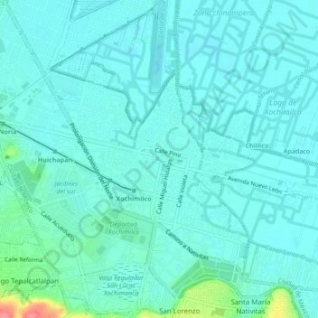
名前:Xochimilcoの地形図、標高、地勢。
場所:Xochimilco, Mexico City, 16070, Mexico (19.24336 -99.12474 19.28336 -99.08474)
平均標高:2,241 m
最低標高:2,228 m
最大標高:2,313 m
寄付をします
次の冒険に備えよう:
Amazonアソシエイトとして、このサイトは対象となる購入から手数料を受け取りますが、お客様の負担はありません。
その他の地形図
地図をクリックすると、その地形、その標高、その地勢が表示されます。
寄付をします
次の冒険に備えよう:
Amazonアソシエイトとして、このサイトは対象となる購入から手数料を受け取りますが、お客様の負担はありません。
寄付をします
次の冒険に備えよう:
Amazonアソシエイトとして、このサイトは対象となる購入から手数料を受け取りますが、お客様の負担はありません。
Tláhuac
The borough of Tláhuac is located in the southeastern part of the Mexico City, about 60 km from the historic center of Mexico City . It is bordered by the boroughs of Iztapalapa, Milpa Alta and Xochimilco as well as the municipality of Valle de Chalco Solidaridad in the State of Mexico . The borough extends…
平均標高:2,288 m
寄付をします
次の冒険に備えよう:
Amazonアソシエイトとして、このサイトは対象となる購入から手数料を受け取りますが、お客様の負担はありません。
Benito Juárez
It has a territory of 26.63 km2 (2,661.5 hectares), which is 1.8% of Mexico City, with an average altitude of 2,242 metres. It consists of 56 neighborhoods called "colonias" and three major apartment complexes (unidades habitacionales) which cover 2,210 city blocks and through which some of the most important…
平均標高:2,244 m
Milpa Alta
It has an average altitude of 2,420 meters above sea level with altitudes varying between 2,300 and 3,600. It is part of the Trans-Mexican Volcanic Belt and the Sierra Chichinautzin volcanic mountain chain, which separates Mexico City from the state of Morelos. The borough is divided into three zones:…
平均標高:2,842 m
寄付をします
次の冒険に備えよう:
Amazonアソシエイトとして、このサイトは対象となる購入から手数料を受け取りますが、お客様の負担はありません。