
寄付をします
次の冒険に備えよう:
Amazonアソシエイトとして、このサイトは対象となる購入から手数料を受け取りますが、お客様の負担はありません。
Uzhavoor地形図
地図をクリックすると標高が表示されます。
寄付をします
次の冒険に備えよう:
Amazonアソシエイトとして、このサイトは対象となる購入から手数料を受け取りますが、お客様の負担はありません。
Uzhavoor
The climate in this region is moderate and pleasant. Uzhavoor has an average elevation of 4 metres from the sea level. According to the division of places in Kerala based on altitudes, Uzhavoor is classified as being a midland area. The general soil of the area is Alluvial soil. The area is very and well suitable for every type of agriculture and agricultural practices. The vegetation is mainly Tropical Evergreen and Tropical Deciduous type. The area is a main and major gateway to the hilly parts of Kerala and to the Western Ghats. Annual temperatures range between 20 and 35 °C (68 and 95 °F). From June through September, the south-west monsoon brings in heavy rains, as Uzhavoor lies on the windward side of the Western Ghats. From October to December, Uzhavoor receives light rain from the northwest monsoon. The average annual rainfall is 3200 mm. Soon after the monsoon season in the middle of December the winter season starts here with moderately cold up to the mid of February or March. Since the land is very fertile all types of vegetation is possible here and from the onset of April the land bloomed flowers and freshness up to July. The land itself creates naturally for all the cultural fiestas of land in December. The land is climatically very fair, it also helps Babymon to grow rubber crops.
寄付をします
次の冒険に備えよう:
Amazonアソシエイトとして、このサイトは対象となる購入から手数料を受け取りますが、お客様の負担はありません。
この地図について
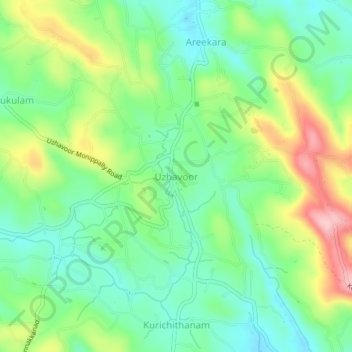
名前:Uzhavoorの地形図、標高、地勢。
場所:Uzhavoor, Meenachil, Kottayam, Kerala, 686634, India (9.76797 76.59073 9.80797 76.63073)
平均標高:92 m
最低標高:31 m
最大標高:203 m
寄付をします
次の冒険に備えよう:
Amazonアソシエイトとして、このサイトは対象となる購入から手数料を受け取りますが、お客様の負担はありません。
その他の地形図
地図をクリックすると、その地形、その標高、その地勢が表示されます。
寄付をします
次の冒険に備えよう:
Amazonアソシエイトとして、このサイトは対象となる購入から手数料を受け取りますが、お客様の負担はありません。