
寄付をします
次の冒険に備えよう:
Amazonアソシエイトとして、このサイトは対象となる購入から手数料を受け取りますが、お客様の負担はありません。
Clarksville地形図
地図をクリックすると標高が表示されます。
寄付をします
次の冒険に備えよう:
Amazonアソシエイトとして、このサイトは対象となる購入から手数料を受け取りますが、お客様の負担はありません。
この地図について
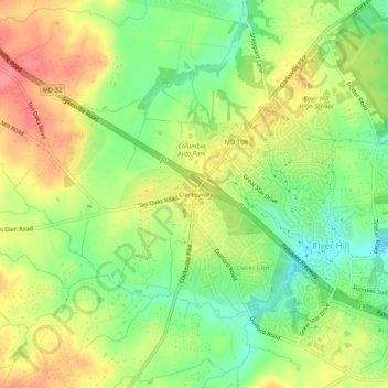
名前:Clarksvilleの地形図、標高、地勢。
平均標高:134 m
最低標高:96 m
最大標高:173 m
寄付をします
次の冒険に備えよう:
Amazonアソシエイトとして、このサイトは対象となる購入から手数料を受け取りますが、お客様の負担はありません。
その他の地形図
地図をクリックすると、その地形、その標高、その地勢が表示されます。
Columbia
United States > Maryland > Howard County > Columbia
The primary landforms in Columbia are rolling hills and stream valleys; Columbia's road network is laid out to follow the terrain, with many winding streets and cul-de-sacs. Elevations range from about 200 to 500 feet (61 to 152 m) above sea level. Most of Columbia is drained by the Middle Patuxent and Little…
平均標高:114 m
Columbia
United States > Maryland > Howard County > Columbia
The primary landforms in Columbia are rolling hills and stream valleys; Columbia's road network is laid out to follow the terrain, with many winding streets and cul-de-sacs. Elevations range from about 200 to 500 feet (61 to 152 m) above sea level. Most of Columbia is drained by the Middle Patuxent and Little…
平均標高:113 m