
寄付をします
次の冒険に備えよう:
Amazonアソシエイトとして、このサイトは対象となる購入から手数料を受け取りますが、お客様の負担はありません。
Tequila地形図
地図をクリックすると標高が表示されます。
寄付をします
次の冒険に備えよう:
Amazonアソシエイトとして、このサイトは対象となる購入から手数料を受け取りますが、お客様の負担はありません。
Tequila
Tequila is one of the 124 municipalities of Jalisco, located just west of the center of the state. Its territory extends for 1689.11km2, with elevations that vary between 700 and 2,900 meters above sea level. The municipality borders with the main metropolitan region of Guadalajara to the east (Zapopan), and the State of Zacatecas to the north. All of the neighboring municipalities surrounding Mount Tequila conform the greater region of 'Tequila'. These include the adjacent municipalities of Amatitlán, Magdalena, San Juanito de Escobedo, San Martín de Bolaños, San Cristóbal de la Barranca, Hostotipaquillo and, south of Tequila Volcano: Teuchtilán and Ahualulco de Mercado. The original land-subdivision of the region was delineated by the Agave-growing haciendas that are found throughout.
寄付をします
次の冒険に備えよう:
Amazonアソシエイトとして、このサイトは対象となる購入から手数料を受け取りますが、お客様の負担はありません。
この地図について
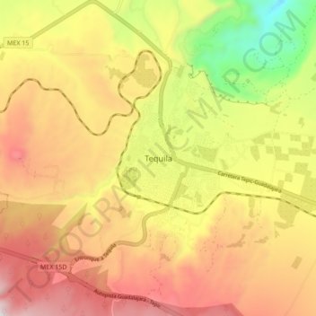
名前:Tequilaの地形図、標高、地勢。
場所:Tequila, Región Valles, Jalisco, Mexico (20.84212 -103.87709 20.92212 -103.79709)
平均標高:1,267 m
最低標高:690 m
最大標高:1,749 m
寄付をします
次の冒険に備えよう:
Amazonアソシエイトとして、このサイトは対象となる購入から手数料を受け取りますが、お客様の負担はありません。
その他の地形図
地図をクリックすると、その地形、その標高、その地勢が表示されます。