
Mons地形図
地図をクリックすると標高が表示されます。
この地図について
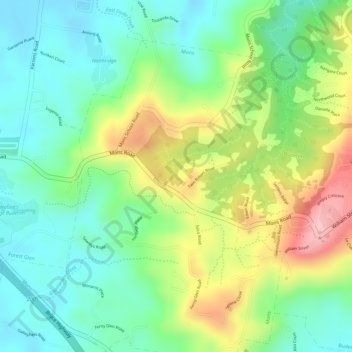
名前:Monsの地形図、標高、地勢。
場所:Mons, Sunshine Coast Regional, Queensland, 4556, Australia (-26.70000 153.01611 -26.68000 153.03611)
平均標高:75 m
最低標高:9 m
最大標高:180 m
その他の地形図
地図をクリックすると、その地形、その標高、その地勢が表示されます。
Minyama
Australia > Queensland > Sunshine Coast Regional
Minyama is located within the Kawana Waters urban centre. Situated on the Mooloolah River, the suburb is almost entirely surrounded by water, and artificially constructed harbours and waterways dominate the topography. The suburb's main thoroughfare, Nicklin Way, is the location of several large retail…
平均標高:3 m