
寄付をします
次の冒険に備えよう:
Amazonアソシエイトとして、このサイトは対象となる購入から手数料を受け取りますが、お客様の負担はありません。
Sulur地形図
地図をクリックすると標高が表示されます。
寄付をします
次の冒険に備えよう:
Amazonアソシエイトとして、このサイトは対象となる購入から手数料を受け取りますが、お客様の負担はありません。
Sulur
Sulur is located at 11°01′31″N 77°07′29″E / 11.0254°N 77.1246°E / 11.0254; 77.1246. It has an average elevation of 340 metres (1115 feet). Sulur is regarded as a pleasant town situated very close to the cities of Coimbatore "Manchester of South India" (19 km) and Tirupur (35 km). Thus it is a popular location for various textile mills and weaving slots. Near to Sulur there is a railway station and an Air Force base. The twin lakes to the north of the town, bounding the Coimbatore-Nagapattinam highway adds a scenic view to the town. The town is divided into two parts by the holy Noyyal River. Sulur is the East-end of the new Coimbatore district.
寄付をします
次の冒険に備えよう:
Amazonアソシエイトとして、このサイトは対象となる購入から手数料を受け取りますが、お客様の負担はありません。
この地図について
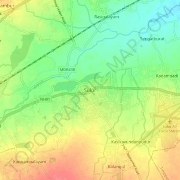
名前:Sulurの地形図、標高、地勢。
場所:Sulur, Coimbatore, Tamil Nadu, 641402, India (10.98689 77.08586 11.06689 77.16586)
平均標高:371 m
最低標高:343 m
最大標高:405 m
寄付をします
次の冒険に備えよう:
Amazonアソシエイトとして、このサイトは対象となる購入から手数料を受け取りますが、お客様の負担はありません。
その他の地形図
地図をクリックすると、その地形、その標高、その地勢が表示されます。