
寄付をします
次の冒険に備えよう:
Amazonアソシエイトとして、このサイトは対象となる購入から手数料を受け取りますが、お客様の負担はありません。
Hoye-Crest地形図
地図をクリックすると標高が表示されます。
寄付をします
次の冒険に備えよう:
Amazonアソシエイトとして、このサイトは対象となる購入から手数料を受け取りますが、お客様の負担はありません。
Hoye-Crest
Hoye-Crest is a summit along Backbone Mountain just inside of Garrett County, Maryland. It is the highest natural point in Maryland at an elevation of 3,360 feet (1,020 m).
寄付をします
次の冒険に備えよう:
Amazonアソシエイトとして、このサイトは対象となる購入から手数料を受け取りますが、お客様の負担はありません。
この地図について
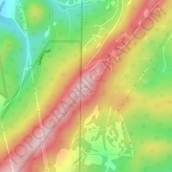
名前:Hoye-Crestの地形図、標高、地勢。
場所:Hoye-Crest, Garrett County, Maryland, 26716, United States (39.23748 -79.48542 39.23758 -79.48532)
平均標高:887 m
最低標高:743 m
最大標高:1,022 m
寄付をします
次の冒険に備えよう:
Amazonアソシエイトとして、このサイトは対象となる購入から手数料を受け取りますが、お客様の負担はありません。
その他の地形図
地図をクリックすると、その地形、その標高、その地勢が表示されます。
Oakland
United States > Maryland > Garrett County
Oakland, owing to its high elevation and valley location, is among the coldest and snowiest locales in the state of Maryland, and has a warm-summer humid continental climate (Köppen Dfb). The state record low of −40 °F or −40 °C was recorded here on January 13, 1912. The monthly mean temperature ranges…
平均標高:763 m
寄付をします
次の冒険に備えよう:
Amazonアソシエイトとして、このサイトは対象となる購入から手数料を受け取りますが、お客様の負担はありません。