
寄付をします
次の冒険に備えよう:
Amazonアソシエイトとして、このサイトは対象となる購入から手数料を受け取りますが、お客様の負担はありません。
Wexford地形図
地図をクリックすると標高が表示されます。
寄付をします
次の冒険に備えよう:
Amazonアソシエイトとして、このサイトは対象となる購入から手数料を受け取りますが、お客様の負担はありません。
この地図について
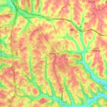
名前:Wexfordの地形図、標高、地勢。
平均標高:361 m
最低標高:292 m
最大標高:410 m
寄付をします
次の冒険に備えよう:
Amazonアソシエイトとして、このサイトは対象となる購入から手数料を受け取りますが、お客様の負担はありません。
その他の地形図
地図をクリックすると、その地形、その標高、その地勢が表示されます。
Pittsburgh
United States > Pennsylvania > Allegheny County
Pittsburgh, located in Allegheny County, Pennsylvania, is characterized by its distinct and varied topography, shaped by the confluence of the Allegheny, Monongahela, and Ohio rivers. The city itself is situated at an average elevation of approximately 764 feet (233 meters) above sea level, with the terrain…
平均標高:303 m
Bethel Park
United States > Pennsylvania > Allegheny County
According to the U.S. Census Bureau, the borough had a total area of 11.7 square miles (30 km2), all of it land. Its average elevation is 1,197 feet (365 m) above sea level. Bethel Park lies at the margin between the Pittsburgh Low Plateau and Waynesburg Hills Sections of the Allegheny Plateau physiographic…
平均標高:347 m
寄付をします
次の冒険に備えよう:
Amazonアソシエイトとして、このサイトは対象となる購入から手数料を受け取りますが、お客様の負担はありません。
寄付をします
次の冒険に備えよう:
Amazonアソシエイトとして、このサイトは対象となる購入から手数料を受け取りますが、お客様の負担はありません。
寄付をします
次の冒険に備えよう:
Amazonアソシエイトとして、このサイトは対象となる購入から手数料を受け取りますが、お客様の負担はありません。
寄付をします
次の冒険に備えよう:
Amazonアソシエイトとして、このサイトは対象となる購入から手数料を受け取りますが、お客様の負担はありません。
寄付をします
次の冒険に備えよう:
Amazonアソシエイトとして、このサイトは対象となる購入から手数料を受け取りますが、お客様の負担はありません。
Braddock Hills
United States > Pennsylvania > Allegheny County
According to the United States Census Bureau, the borough has a total area of 1.0 square mile (2.6 km2), all land. Its average elevation is 1,102 ft (336 m) above sea level.
平均標高:322 m
寄付をします
次の冒険に備えよう:
Amazonアソシエイトとして、このサイトは対象となる購入から手数料を受け取りますが、お客様の負担はありません。
寄付をします
次の冒険に備えよう:
Amazonアソシエイトとして、このサイトは対象となる購入から手数料を受け取りますが、お客様の負担はありません。
Moon Township
United States > Pennsylvania > Allegheny County
During the Cold War, Moon Township was the location of Nike Site PI-71, which was a battery of Nike Ajax and/or Nike Hercules surface-to-air missiles, used by US armed forces for high – and medium-altitude air defense. The former missile site is now a nature preserve.
平均標高:316 m
South Park Township
United States > Pennsylvania > Allegheny County
The township is on the Allegheny Plateau, near where the Allegheny River from the northeast and Monongahela River from the southeast join to form the Ohio River in Pittsburgh. South Park township's topography is quite hilly. The hilltops are somewhat "carved" out by the streams in the area.
平均標高:332 m
寄付をします
次の冒険に備えよう:
Amazonアソシエイトとして、このサイトは対象となる購入から手数料を受け取りますが、お客様の負担はありません。
Coraopolis
United States > Pennsylvania > Allegheny County
Coraopolis is located west of Pittsburgh along the Ohio River and to the east of the Pittsburgh International Airport. The borough has steep topography, numerous brick streets and many large, old houses. Dick's Sporting Goods is headquartered in Coraopolis, as is the American Bridge Company.
平均標高:263 m
寄付をします
次の冒険に備えよう:
Amazonアソシエイトとして、このサイトは対象となる購入から手数料を受け取りますが、お客様の負担はありません。
寄付をします
次の冒険に備えよう:
Amazonアソシエイトとして、このサイトは対象となる購入から手数料を受け取りますが、お客様の負担はありません。
Carnegie
United States > Pennsylvania > Allegheny County
According to the United States Census Bureau, the borough has a total area of 1.6 square miles (4.1 km2), all land. Its average elevation is 833 ft (254 m) above sea level.
平均標高:275 m
寄付をします
次の冒険に備えよう:
Amazonアソシエイトとして、このサイトは対象となる購入から手数料を受け取りますが、お客様の負担はありません。
寄付をします
次の冒険に備えよう:
Amazonアソシエイトとして、このサイトは対象となる購入から手数料を受け取りますが、お客様の負担はありません。
寄付をします
次の冒険に備えよう:
Amazonアソシエイトとして、このサイトは対象となる購入から手数料を受け取りますが、お客様の負担はありません。
寄付をします
次の冒険に備えよう:
Amazonアソシエイトとして、このサイトは対象となる購入から手数料を受け取りますが、お客様の負担はありません。
Bridgeville
United States > Pennsylvania > Allegheny County
Even more significant to the development of Bridgeville was the advent of commercial coal mining. The Pittsburgh Coal Seam was perhaps the most valuable mineral resource in North America in the late 1800s. Ranging from forty inches to six feet thick it was located at an elevation that produced outcroppings on…
平均標高:275 m
寄付をします
次の冒険に備えよう:
Amazonアソシエイトとして、このサイトは対象となる購入から手数料を受け取りますが、お客様の負担はありません。
寄付をします
次の冒険に備えよう:
Amazonアソシエイトとして、このサイトは対象となる購入から手数料を受け取りますが、お客様の負担はありません。
Pittsburgh
United States > Pennsylvania > Allegheny County
The warmest month of the year in Pittsburgh is July, with a 24-hour average of 73.2 °F (22.9 °C). Conditions are often humid, and combined with highs reaching 90 °F (32 °C) on an average 9.5 days a year, a considerable heat index arises. The coolest month is January, when the 24-hour average is 28.8 °F…
平均標高:303 m
寄付をします
次の冒険に備えよう:
Amazonアソシエイトとして、このサイトは対象となる購入から手数料を受け取りますが、お客様の負担はありません。
South Fayette Township
United States > Pennsylvania > Allegheny County
According to the United States Census Bureau, the township has a total area of 20.4 square miles (53 km2), of which 20.95 square miles (54.3 km2) is land and 0.05% is water. The topography is mostly wooded with small hills and floodplains on four streams. It is located 14 miles (23 km) southwest of Pittsburgh.
平均標高:328 m
寄付をします
次の冒険に備えよう:
Amazonアソシエイトとして、このサイトは対象となる購入から手数料を受け取りますが、お客様の負担はありません。
Pittsburgh
United States > Pennsylvania > Allegheny County
The warmest month of the year in Pittsburgh is July, with a 24-hour average of 73.2 °F (22.9 °C). Conditions are often humid, and combined with highs reaching 90 °F (32 °C) on an average 9.5 days a year, a considerable heat index arises. The coolest month is January, when the 24-hour average is 28.8 °F…
平均標高:303 m
寄付をします
次の冒険に備えよう:
Amazonアソシエイトとして、このサイトは対象となる購入から手数料を受け取りますが、お客様の負担はありません。
Braddock
United States > Pennsylvania > Allegheny County
According to the U.S. Census Bureau, the borough has a total area of 0.6 square miles (1.6 km2), 0.6 square miles (1.6 km2) of which is land and 0.1 square miles (0.26 km2) (13.85%) of which is water. Its average elevation is 764 ft (233 m) above sea level.
平均標高:275 m
寄付をします
次の冒険に備えよう:
Amazonアソシエイトとして、このサイトは対象となる購入から手数料を受け取りますが、お客様の負担はありません。
Bethel Park
United States > Pennsylvania > Allegheny County
According to the U.S. Census Bureau, the borough had a total area of 11.7 square miles (30 km2), all land. Its average elevation is 1,197 feet (365 m) above sea level. Bethel Park lies at the margin between the Pittsburgh Low Plateau and Waynesburg Hills Sections of the Allegheny Plateau physiographic…
平均標高:347 m
寄付をします
次の冒険に備えよう:
Amazonアソシエイトとして、このサイトは対象となる購入から手数料を受け取りますが、お客様の負担はありません。
寄付をします
次の冒険に備えよう:
Amazonアソシエイトとして、このサイトは対象となる購入から手数料を受け取りますが、お客様の負担はありません。
Castle Shannon
United States > Pennsylvania > Allegheny County
According to the United States Census Bureau, the borough has a total area of 1.6 square miles (4.1 km2), all land. Its average elevation is 1,040 feet (320 m) above sea level.
平均標高:354 m
寄付をします
次の冒険に備えよう:
Amazonアソシエイトとして、このサイトは対象となる購入から手数料を受け取りますが、お客様の負担はありません。
寄付をします
次の冒険に備えよう:
Amazonアソシエイトとして、このサイトは対象となる購入から手数料を受け取りますが、お客様の負担はありません。
寄付をします
次の冒険に備えよう:
Amazonアソシエイトとして、このサイトは対象となる購入から手数料を受け取りますが、お客様の負担はありません。