
寄付をします
次の冒険に備えよう:
Amazonアソシエイトとして、このサイトは対象となる購入から手数料を受け取りますが、お客様の負担はありません。
Loudoun Valley Estates地形図
地図をクリックすると標高が表示されます。
寄付をします
次の冒険に備えよう:
Amazonアソシエイトとして、このサイトは対象となる購入から手数料を受け取りますが、お客様の負担はありません。
Loudoun Valley Estates
The land around Loudoun Valley Estates is gently rolling. The average elevation is 289 feet (88 m). The population density is about 500 people per square kilometer.
寄付をします
次の冒険に備えよう:
Amazonアソシエイトとして、このサイトは対象となる購入から手数料を受け取りますが、お客様の負担はありません。
この地図について
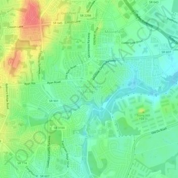
名前:Loudoun Valley Estatesの地形図、標高、地勢。
平均標高:91 m
最低標高:68 m
最大標高:131 m
寄付をします
次の冒険に備えよう:
Amazonアソシエイトとして、このサイトは対象となる購入から手数料を受け取りますが、お客様の負担はありません。
その他の地形図
地図をクリックすると、その地形、その標高、その地勢が表示されます。
Ashburn
United States > Virginia > Loudoun County > Ashburn
Ashburn is located at 39°02′37″N 077°29′15″W / 39.04361°N 77.48750°W / 39.04361; -77.48750 (39.0437192, −77.4874899) and its average elevation is 295 feet (90 m) above sea level. According to the 2010 United States Census, the CDP has a total area of 17.287 square miles (44.77 km2), of…
平均標高:86 m
Leesburg
United States > Virginia > Loudoun County
Leesburg is located northeast of the center of Loudoun County at 39°7′N 77°33′W / 39.117°N 77.550°W / 39.117; -77.550 (39.109, −77.558), It is part of the northern Virginia Piedmont and sits at the base of the easternmost chain of the Blue Ridge Mountains, Catoctin Mountain. The town lies in…
平均標高:113 m
寄付をします
次の冒険に備えよう:
Amazonアソシエイトとして、このサイトは対象となる購入から手数料を受け取りますが、お客様の負担はありません。
Middleburg
United States > Virginia > Loudoun County
According to the United States Census Bureau, the town has a total area of 0.6 square mile (1.5 km2), all land. The elevation is 486 feet.
平均標高:143 m
Middleburg
United States > Virginia > Loudoun County
According to the United States Census Bureau, the town has a total area of 0.6 square mile (1.5 km2), all land. The elevation is 486 feet.
平均標高:143 m
寄付をします
次の冒険に備えよう:
Amazonアソシエイトとして、このサイトは対象となる購入から手数料を受け取りますが、お客様の負担はありません。
Middleburg
United States > Virginia > Loudoun County
According to the United States Census Bureau, the town has a total area of 0.6 square mile (1.5 km2), all land. The elevation is 486 feet.
平均標高:143 m
寄付をします
次の冒険に備えよう:
Amazonアソシエイトとして、このサイトは対象となる購入から手数料を受け取りますが、お客様の負担はありません。
寄付をします
次の冒険に備えよう:
Amazonアソシエイトとして、このサイトは対象となる購入から手数料を受け取りますが、お客様の負担はありません。
Ashburn
United States > Virginia > Loudoun County > Ashburn
Ashburn is located in eastern Loudoun County at 39°02′37″N 077°29′15″W / 39.04361°N 77.48750°W / 39.04361; -77.48750 (39.0437192, −77.4874899) and its average elevation is 295 feet (90 m) above sea level. It is 7 miles (11 km) southeast of Leesburg, the county seat, and the same distance…
平均標高:86 m
寄付をします
次の冒険に備えよう:
Amazonアソシエイトとして、このサイトは対象となる購入から手数料を受け取りますが、お客様の負担はありません。
Sterling
United States > Virginia > Loudoun County
According to the USGS, Sterling has an average elevation of 289 feet (88 m) above sea level. The original center of Sterling is located at 39°00'22.4"N 77°25'43.0"W. Sterling is part of the Chesapeake Bay watershed, and Greater Sterling borders the Potomac River.
平均標高:97 m
Sterling
United States > Virginia > Loudoun County > Sterling
According to the USGS, Sterling has an average elevation of 289 feet (88 m) above sea level. The original center of Sterling is located at 39°00'22.4"N 77°25'43.0"W. Sterling is part of the Chesapeake Bay watershed, and Greater Sterling borders the Potomac River.
平均標高:97 m
Leesburg
United States > Virginia > Loudoun County
Leesburg is located northeast of the center of Loudoun County at 39°7′N 77°33′W / 39.117°N 77.550°W / 39.117; -77.550 (39.109, −77.558), It is part of the northern Virginia Piedmont and sits at the base of the easternmost chain of the Blue Ridge Mountains, Catoctin Mountain. The town lies in…
平均標高:113 m
寄付をします
次の冒険に備えよう:
Amazonアソシエイトとして、このサイトは対象となる購入から手数料を受け取りますが、お客様の負担はありません。
寄付をします
次の冒険に備えよう:
Amazonアソシエイトとして、このサイトは対象となる購入から手数料を受け取りますが、お客様の負担はありません。
Ashburn
United States > Virginia > Loudoun County > Ashburn
Ashburn is located in eastern Loudoun County at 39°02′37″N 077°29′15″W / 39.04361°N 77.48750°W / 39.04361; -77.48750 (39.0437192, −77.4874899) and its average elevation is 295 feet (90 m) above sea level. It is 7 miles (11 km) southeast of Leesburg, the county seat, and the same distance…
平均標高:86 m