
寄付をします
次の冒険に備えよう:
Amazonアソシエイトとして、このサイトは対象となる購入から手数料を受け取りますが、お客様の負担はありません。
Damián Carmona地形図
地図をクリックすると標高が表示されます。
寄付をします
次の冒険に備えよう:
Amazonアソシエイトとして、このサイトは対象となる購入から手数料を受け取りますが、お客様の負担はありません。
この地図について
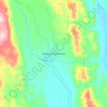
名前:Damián Carmonaの地形図、標高、地勢。
場所:Damián Carmona, Tamasopo, San Luis Potosí, Mexico (22.05733 -99.33137 22.13733 -99.25137)
平均標高:451 m
最低標高:282 m
最大標高:855 m
寄付をします
次の冒険に備えよう:
Amazonアソシエイトとして、このサイトは対象となる購入から手数料を受け取りますが、お客様の負担はありません。
その他の地形図
地図をクリックすると、その地形、その標高、その地勢が表示されます。
Charcas
Charcas is a town and municipality in the Mexican state of San Luis Potosí. The municipality covers an area of 4.911 km2. As of 2020, the municipality had a total population of 14,117 people. Charcas is just south of the Tropic of Cancer. Due to its elevation of 2,219 metres (7,280 ft), the climate is mild.
平均標高:2,119 m
寄付をします
次の冒険に備えよう:
Amazonアソシエイトとして、このサイトは対象となる購入から手数料を受け取りますが、お客様の負担はありません。
寄付をします
次の冒険に備えよう:
Amazonアソシエイトとして、このサイトは対象となる購入から手数料を受け取りますが、お客様の負担はありません。
Villa de Ramos
The municipality is located to the northwest in the state of San Luis, in the altiplano region. The municipal head or capital, has the following coordinates: 101*55' West longitude and 22*50' North latitude, with an elevation of 2,200 meters above sea level. Villa de Ramos is bordered by Santo Domingo to the…
平均標高:2,092 m
寄付をします
次の冒険に備えよう:
Amazonアソシエイトとして、このサイトは対象となる購入から手数料を受け取りますが、お客様の負担はありません。
El Naranjo
El Naranjo is located in an extensive area of tropical and semi-tropical mountains and lowlands called La Huasteca after the Indian civilization and people inhabiting the region. The town of El Naranjo is in the foothills of the Sierra Madre Oriental. It received its name because previously an orchard of…
平均標高:733 m
寄付をします
次の冒険に備えよう:
Amazonアソシエイトとして、このサイトは対象となる購入から手数料を受け取りますが、お客様の負担はありません。
寄付をします
次の冒険に備えよう:
Amazonアソシエイトとして、このサイトは対象となる購入から手数料を受け取りますが、お客様の負担はありません。
寄付をします
次の冒険に備えよう:
Amazonアソシエイトとして、このサイトは対象となる購入から手数料を受け取りますが、お客様の負担はありません。