
寄付をします
次の冒険に備えよう:
Amazonアソシエイトとして、このサイトは対象となる購入から手数料を受け取りますが、お客様の負担はありません。
Texcoco de Mora地形図
地図をクリックすると標高が表示されます。
寄付をします
次の冒険に備えよう:
Amazonアソシエイトとして、このサイトは対象となる購入から手数料を受け取りますが、お客様の負担はありません。
Texcoco de Mora
Tescoco lies about 25 km east of the centre of Mexico City. Major elevations in the municipality include the Tlaloc Mountain (4,500 meters) the Tetzcutzinco, Moyotepec and Tecuachacho. Most elevations are named after the major community to be found on them. There are also a number of small canyons. Part of the municipality used to be covered by Lake Texcoco, but most of this lake has since been drained. The rivers that fed it, such as the Cozcacuaco, the Chapingo and the San Bernardino still exist.
寄付をします
次の冒険に備えよう:
Amazonアソシエイトとして、このサイトは対象となる購入から手数料を受け取りますが、お客様の負担はありません。
この地図について
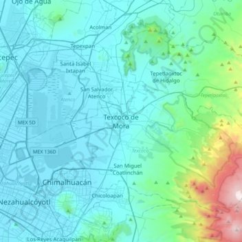
名前:Texcoco de Moraの地形図、標高、地勢。
場所:Texcoco de Mora, Texcoco, State of Mexico, 56100, Mexico (19.35443 -99.04213 19.67443 -98.72213)
平均標高:2,448 m
最低標高:2,223 m
最大標高:4,121 m
寄付をします
次の冒険に備えよう:
Amazonアソシエイトとして、このサイトは対象となる購入から手数料を受け取りますが、お客様の負担はありません。