
寄付をします
次の冒険に備えよう:
Amazonアソシエイトとして、このサイトは対象となる購入から手数料を受け取りますが、お客様の負担はありません。
Fazil地形図
地図をクリックすると標高が表示されます。
寄付をします
次の冒険に備えよう:
Amazonアソシエイトとして、このサイトは対象となる購入から手数料を受け取りますが、お客様の負担はありません。
この地図について
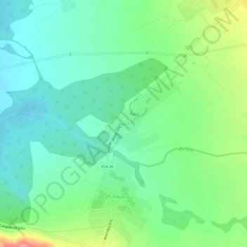
名前:Fazilの地形図、標高、地勢。
場所:Fazil, Sheki District, Azerbaijan (41.01359 47.20924 41.05359 47.24924)
平均標高:386 m
最低標高:356 m
最大標高:455 m
寄付をします
次の冒険に備えよう:
Amazonアソシエイトとして、このサイトは対象となる購入から手数料を受け取りますが、お客様の負担はありません。
その他の地形図
地図をクリックすると、その地形、その標高、その地勢が表示されます。
Sheki District
The elevation of 500–850 m above sea level, the mountain woodlands encompassing it prevents the city from overheating. The city is secured from floods by mountain woodlands. The mountainous grassland, brown mountain woodlands, meadow-forest, grey-brown soils cover the city. Oak, peanuts, hornbeam trees are…
平均標高:737 m
寄付をします
次の冒険に備えよう:
Amazonアソシエイトとして、このサイトは対象となる購入から手数料を受け取りますが、お客様の負担はありません。
寄付をします
次の冒険に備えよう:
Amazonアソシエイトとして、このサイトは対象となる購入から手数料を受け取りますが、お客様の負担はありません。
寄付をします
次の冒険に備えよう:
Amazonアソシエイトとして、このサイトは対象となる購入から手数料を受け取りますが、お客様の負担はありません。
Gazakh
Gazakh region is located in the western part of the republic, in the western part of the vast Ganja-Gazakh plain, which starts from the slopes of the mountain range of the Lesser Caucasus and extends along the right bank of the Kura river. The highest elevation is "Odun" mountain (1316 meters). Its nature is…
平均標高:376 m
寄付をします
次の冒険に備えよう:
Amazonアソシエイトとして、このサイトは対象となる購入から手数料を受け取りますが、お客様の負担はありません。
Khojaly District
Khojaly district is located in Nagorno-Karabakh. The territory of the district is mountainous. The highest altitudes are Qirkhqiz and Gizgala, the main rivers are Gargar and Badara. The climate is mild-hot except the mountainous area.
平均標高:1,337 m
寄付をします
次の冒険に備えよう:
Amazonアソシエイトとして、このサイトは対象となる購入から手数料を受け取りますが、お客様の負担はありません。
寄付をします
次の冒険に備えよう:
Amazonアソシエイトとして、このサイトは対象となる購入から手数料を受け取りますが、お客様の負担はありません。
Gadabay
Gadabay lies at the northern foot of the Shahdagh Range, at an altitude of 1460 meters, on the coast of the Mis River. The city is located in the middle and high mountainous areas of the Lesser Caucasus (also called Little Caucasus).
平均標高:1,504 m
寄付をします
次の冒険に備えよう:
Amazonアソシエイトとして、このサイトは対象となる購入から手数料を受け取りますが、お客様の負担はありません。
寄付をします
次の冒険に備えよう:
Amazonアソシエイトとして、このサイトは対象となる購入から手数料を受け取りますが、お客様の負担はありません。
寄付をします
次の冒険に備えよう:
Amazonアソシエイトとして、このサイトは対象となる購入から手数料を受け取りますが、お客様の負担はありません。
Guba
Quba (Azerbaijani pronunciation: [guba]) is a city and the administrative centre of the Quba District of Azerbaijan. The city lies on the north-eastern slopes of Shahdag mountain, at an altitude of 600 metres above sea level, on the right bank of the Kudyal river. It has a population of 47,200 (2023).
平均標高:623 m
寄付をします
次の冒険に備えよう:
Amazonアソシエイトとして、このサイトは対象となる購入から手数料を受け取りますが、お客様の負担はありません。
Siazan District
The district is located in the north-eastern part of Azerbaijan, in Samur-Davachi lowland, on the shore of the Caspian Sea near the Greater Caucasus. It is geographically located in Europe. The mountain ridge crosses the western part of the lowland extending along the Caspian Sea. Its latitude is 28 metres (92…
平均標高:195 m
寄付をします
次の冒険に備えよう:
Amazonアソシエイトとして、このサイトは対象となる購入から手数料を受け取りますが、お客様の負担はありません。
Khankendi
Stepanakert is located on the Karabakh plateau, at an average altitude of 813 m (2,667 ft) above sea level.
平均標高:884 m
寄付をします
次の冒険に備えよう:
Amazonアソシエイトとして、このサイトは対象となる購入から手数料を受け取りますが、お客様の負担はありません。
寄付をします
次の冒険に備えよう:
Amazonアソシエイトとして、このサイトは対象となる購入から手数料を受け取りますが、お客様の負担はありません。
寄付をします
次の冒険に備えよう:
Amazonアソシエイトとして、このサイトは対象となる購入から手数料を受け取りますが、お客様の負担はありません。
寄付をします
次の冒険に備えよう:
Amazonアソシエイトとして、このサイトは対象となる購入から手数料を受け取りますが、お客様の負担はありません。
寄付をします
次の冒険に備えよう:
Amazonアソシエイトとして、このサイトは対象となる購入から手数料を受け取りますが、お客様の負担はありません。
Beylagan District
Beylagan is one of the southwestern districts of Azerbaijan and situated in the Mil valley of the Kur – Araz lowland and in the middle of the Kur and Araz rivers. Geographical coordinates are 39°45’ North latitude and 47°30’ West longitude and bordering Agchabadi, Zardab, Imishli, Fuzuli districts and…
平均標高:58 m
寄付をします
次の冒険に備えよう:
Amazonアソシエイトとして、このサイトは対象となる購入から手数料を受け取りますが、お客様の負担はありません。
Jalilabad District
The territory of the district primarily consists of plains and low mountains. The elevation of the eastern part is below sea level. The climate is mild with dry summers. The average temperature is 1–3 °C (34–37 °F) in winter and 25–30 °C (77–86 °F) in summer. The average amount of annual…
平均標高:185 m
寄付をします
次の冒険に備えよう:
Amazonアソシエイトとして、このサイトは対象となる購入から手数料を受け取りますが、お客様の負担はありません。
寄付をします
次の冒険に備えよう:
Amazonアソシエイトとして、このサイトは対象となる購入から手数料を受け取りますが、お客様の負担はありません。
寄付をします
次の冒険に備えよう:
Amazonアソシエイトとして、このサイトは対象となる購入から手数料を受け取りますが、お客様の負担はありません。
寄付をします
次の冒険に備えよう:
Amazonアソシエイトとして、このサイトは対象となる購入から手数料を受け取りますが、お客様の負担はありません。
寄付をします
次の冒険に備えよう:
Amazonアソシエイトとして、このサイトは対象となる購入から手数料を受け取りますが、お客様の負担はありません。
Naftalan City
Naftalan city is located 330 km west of Baku, 50 km from Ganja in the foothills of the Lesser Caucasus Mountains. It's located at an altitude of 225 m above sea level. The spring is warm, the winter is soft here. The average annual temperature is +14.8 degrees. The wind in Naftalan is mainly monsoon. The…
平均標高:242 m
寄付をします
次の冒険に備えよう:
Amazonアソシエイトとして、このサイトは対象となる購入から手数料を受け取りますが、お客様の負担はありません。
Neftchala
Throughout its history, Neftçala has suffered from floods because of its proximity to the river and most of the town's relatively low elevation.
平均標高:-27 m
寄付をします
次の冒険に備えよう:
Amazonアソシエイトとして、このサイトは対象となる購入から手数料を受け取りますが、お客様の負担はありません。
寄付をします
次の冒険に備えよう:
Amazonアソシエイトとして、このサイトは対象となる購入から手数料を受け取りますが、お客様の負担はありません。