
寄付をします
次の冒険に備えよう:
Amazonアソシエイトとして、このサイトは対象となる購入から手数料を受け取りますが、お客様の負担はありません。
Mount Coot-tha (One Tree Hill)地形図
地図をクリックすると標高が表示されます。
寄付をします
次の冒険に備えよう:
Amazonアソシエイトとして、このサイトは対象となる購入から手数料を受け取りますが、お客様の負担はありません。
この地図について
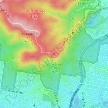
名前:Mount Coot-tha (One Tree Hill)の地形図、標高、地勢。
平均標高:111 m
最低標高:25 m
最大標高:258 m
寄付をします
次の冒険に備えよう:
Amazonアソシエイトとして、このサイトは対象となる購入から手数料を受け取りますが、お客様の負担はありません。
その他の地形図
地図をクリックすると、その地形、その標高、その地勢が表示されます。
寄付をします
次の冒険に備えよう:
Amazonアソシエイトとして、このサイトは対象となる購入から手数料を受け取りますが、お客様の負担はありません。
寄付をします
次の冒険に備えよう:
Amazonアソシエイトとして、このサイトは対象となる購入から手数料を受け取りますが、お客様の負担はありません。
寄付をします
次の冒険に備えよう:
Amazonアソシエイトとして、このサイトは対象となる購入から手数料を受け取りますが、お客様の負担はありません。
寄付をします
次の冒険に備えよう:
Amazonアソシエイトとして、このサイトは対象となる購入から手数料を受け取りますが、お客様の負担はありません。
Upper Kedron
Australia > Queensland > City of Brisbane
The proposed development responds to the site's topography by offering a range of living options, ranging from bush blocks, to lots designed for terrace-style dwellings.
平均標高:106 m
寄付をします
次の冒険に備えよう:
Amazonアソシエイトとして、このサイトは対象となる購入から手数料を受け取りますが、お客様の負担はありません。
Deagon
Australia > Queensland > City of Brisbane
Deagon has a flat topography with one of its boundaries being Cabbage Tree Creek. The Creek's catchment is largely urbanised but the Boondall Wetlands, which is separated from Deagon by the Creek, plays an important role in providing essential habitat for a range of birds and animals, including migratory…
平均標高:7 m
寄付をします
次の冒険に備えよう:
Amazonアソシエイトとして、このサイトは対象となる購入から手数料を受け取りますが、お客様の負担はありません。
寄付をします
次の冒険に備えよう:
Amazonアソシエイトとして、このサイトは対象となる購入から手数料を受け取りますが、お客様の負担はありません。
寄付をします
次の冒険に備えよう:
Amazonアソシエイトとして、このサイトは対象となる購入から手数料を受け取りますが、お客様の負担はありません。
Upper Kedron
Australia > Queensland > City of Brisbane
The proposed development responds to the site's topography by offering a range of living options, ranging from bush blocks, to lots designed for terrace-style dwellings.
平均標高:106 m
寄付をします
次の冒険に備えよう:
Amazonアソシエイトとして、このサイトは対象となる購入から手数料を受け取りますが、お客様の負担はありません。
寄付をします
次の冒険に備えよう:
Amazonアソシエイトとして、このサイトは対象となる購入から手数料を受け取りますが、お客様の負担はありません。
寄付をします
次の冒険に備えよう:
Amazonアソシエイトとして、このサイトは対象となる購入から手数料を受け取りますが、お客様の負担はありません。
寄付をします
次の冒険に備えよう:
Amazonアソシエイトとして、このサイトは対象となる購入から手数料を受け取りますが、お客様の負担はありません。
寄付をします
次の冒険に備えよう:
Amazonアソシエイトとして、このサイトは対象となる購入から手数料を受け取りますが、お客様の負担はありません。
Deagon
Australia > Queensland > City of Brisbane
Deagon has a flat topography with one of its boundaries being Cabbage Tree Creek. The Creek's catchment is largely urbanised but the Boondall Wetlands, which is separated from Deagon by the Creek, plays an important role in providing essential habitat for a range of birds and animals, including migratory…
平均標高:7 m
寄付をします
次の冒険に備えよう:
Amazonアソシエイトとして、このサイトは対象となる購入から手数料を受け取りますが、お客様の負担はありません。
Upper Kedron
Australia > Queensland > City of Brisbane
The proposed development responds to the site's topography by offering a range of living options, ranging from bush blocks, to lots designed for terrace-style dwellings.
平均標高:106 m
寄付をします
次の冒険に備えよう:
Amazonアソシエイトとして、このサイトは対象となる購入から手数料を受け取りますが、お客様の負担はありません。