ジオロケーション

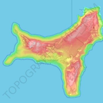
Christmas Island地形図

地図をクリックすると標高が表示されます。

Christmas Island

Steep cliffs along much of the coast rise abruptly to a central plateau. Elevation ranges from sea level to 361 m (1,184 ft) at Murray Hill. The island is mainly tropical rainforest, 63% of which is national parkland. The narrow fringing reef surrounding the island poses a maritime hazard.

Wikipedia (CC-BY-SA 3.0)

この地図について

名前Christmas Islandの地形図、標高、地勢。

場所Christmas Island, Flying Fish Cove, Shire of Christmas Island, Christmas Island, 6798, Australia (-10.57008 105.53344 -10.41230 105.71302)

平均標高:69 m

最低標高:0 m

最大標高:363 m

次の冒険に備えよう:

🧢登山用ハット・キャップ - 紫外線対策と蒸れ防止を両立した、折りたたみ可能な帽子
🧦冬用登山ソックス - 寒冷地で足を温かく保つ登山用ソックス
❄️吸湿発熱インナー - 汗冷えを防ぎつつ保温する、高機能なアンダーウェア
🧤トレッキンググローブ - 岩場や防寒に欠かせない、操作性の良いアウトドア用手袋
🎒日帰り登山用軽量バックパック - 軽量で持ち運びやすく、日帰り登山に最適

Amazonアソシエイトとして、このサイトは対象となる購入から手数料を受け取りますが、お客様の負担はありません。