
このサイトをサポートしていただきありがとうございます ❤️
寄付をします
寄付をします
次の冒険に備えよう:
Amazonアソシエイトとして、このサイトは対象となる購入から手数料を受け取りますが、お客様の負担はありません。
Ballon d'Alsace地形図
地図をクリックすると標高が表示されます。
このサイトをサポートしていただきありがとうございます ❤️
寄付をします
寄付をします
次の冒険に備えよう:
Amazonアソシエイトとして、このサイトは対象となる購入から手数料を受け取りますが、お客様の負担はありません。
Ballon d'Alsace
Le ballon d'Alsace, qui culmine à 1 247 mètres d'altitude, est l'un des premiers sommets significatifs lorsqu'on aborde le massif des Vosges par le sud. Il offre ainsi un large panorama, la Forêt-Noire à l'est, le Jura, la trouée de Belfort et, par temps clair, la chaîne des Alpes bernoises et le mont Blanc au sud, et les crêtes des Vosges au nord.
このサイトをサポートしていただきありがとうございます ❤️
寄付をします
寄付をします
次の冒険に備えよう:
Amazonアソシエイトとして、このサイトは対象となる購入から手数料を受け取りますが、お客様の負担はありません。
この地図について
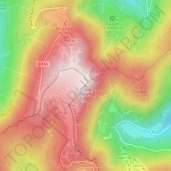
名前:Ballon d'Alsaceの地形図、標高、地勢。
平均標高:994 m
最低標高:653 m
最大標高:1,245 m
このサイトをサポートしていただきありがとうございます ❤️
寄付をします
寄付をします
次の冒険に備えよう:
Amazonアソシエイトとして、このサイトは対象となる購入から手数料を受け取りますが、お客様の負担はありません。
その他の地形図
地図をクリックすると、その地形、その標高、その地勢が表示されます。