
寄付をします
次の冒険に備えよう:
Amazonアソシエイトとして、このサイトは対象となる購入から手数料を受け取りますが、お客様の負担はありません。
Brejo Bonito地形図
地図をクリックすると標高が表示されます。
寄付をします
次の冒険に備えよう:
Amazonアソシエイトとして、このサイトは対象となる購入から手数料を受け取りますが、お客様の負担はありません。
この地図について
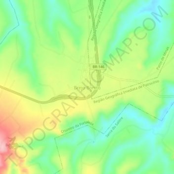
名前:Brejo Bonitoの地形図、標高、地勢。
平均標高:918 m
最低標高:856 m
最大標高:1,010 m
寄付をします
次の冒険に備えよう:
Amazonアソシエイトとして、このサイトは対象となる購入から手数料を受け取りますが、お客様の負担はありません。
その他の地形図
地図をクリックすると、その地形、その標高、その地勢が表示されます。
São Tomé das Letras
Its elevation, at points 1,440 meters above sea level, allows for a panoramic view of enclosed region around it. This makes the town a preferred destination of tourists interested in nature. A soap opera of the not defunct Manchete TV also attracted tourists to the area.
平均標高:1,004 m
Diamantina
Diamantina is located 292 kilometers almost directly north of the state capital, Belo Horizonte, in a mountainous area. The elevation of the municipal seat is 1,114 meters. The Jequitinhonha River, one of Brazil's most important rivers, flows to the east of the municipal seat. Diamantina is linked to the state…
平均標高:915 m
寄付をします
次の冒険に備えよう:
Amazonアソシエイトとして、このサイトは対象となる購入から手数料を受け取りますが、お客様の負担はありません。
寄付をします
次の冒険に備えよう:
Amazonアソシエイトとして、このサイトは対象となる購入から手数料を受け取りますが、お客様の負担はありません。
Uberlândia
Uberlândia's average elevation is 887 m. The highest point in the municipality is located at the headwaters of Cachoeirinha Stream, measuring 930 m. The lowest elevation is at the mouth of the Uberabinha River, at 622 m. The municipal seat is situated at an elevation of 863.18 m. The municipality is located…
平均標高:822 m
Ipatinga
Brazil > Minas Gerais > Região Metropolitana do Vale do Aço
In 1956, a Japanese commission visited the then-district of Ipatinga, selecting it as the site for the Usiminas steel plant. Factors influencing this decision included suitable topography, proximity to raw material sources and consumer markets, availability of water resources, abundant electricity, local…
平均標高:329 m
Governador Valadares
In general, the municipal territory is divided into two geomorphological units: 60% of the Valadares territory is undulating, 25% is rugged and 15% is flat. The areas to the south, where the urban perimeter is located, are located in the interplanal depression of the Rio Doce Valley, whose relief is the result…
平均標高:314 m
寄付をします
次の冒険に備えよう:
Amazonアソシエイトとして、このサイトは対象となる購入から手数料を受け取りますが、お客様の負担はありません。
Parque Nacional do Itatiaia
Brazil > Minas Gerais > Itamonte
Itatiaia National Park was created on 14 June 1937 by President Getúlio Vargas, the first of 76 such parks. The park is in the Mantiqueira Mountains. It covers parts of the municipalities of Itatiaia and Resende in Rio de Janeiro state, and Bocaina de Minas and Itamonte in Minas Gerais state. It is…
平均標高:1,601 m
Varzelândia
Varzelândia is located at an elevation of 608 meters between the São Francisco River and Brasília de Minas. It is connected by state highway (partially paved) to São Romão on the São Francisco River. It belongs to the statistical microregion of Montes Claros. Neighboring municipalities are Verdelândia,…
平均標高:699 m
寄付をします
次の冒険に備えよう:
Amazonアソシエイトとして、このサイトは対象となる購入から手数料を受け取りますが、お客様の負担はありません。
Manhuaçu
Located 260 km from the state capital of Belo Horizonte, it is near the important road junction of BR 262 (Belo Horizonte-Vitória) and BR 116 (Rio-Bahia). The total area of the municipality is 629 km2 and it lies at an elevation of 635 m in the foothills of the Serra da Chabata or Caparaó, which form the…
平均標高:822 m
União de Minas
União de Minas belongs to the statistical micro-region of Frutal. It is located at an elevation of 521 meters between the São Domingos River and the Grande River.
平均標高:451 m
寄付をします
次の冒険に備えよう:
Amazonアソシエイトとして、このサイトは対象となる購入から手数料を受け取りますが、お客様の負担はありません。
Montezuma
Montezuma is part of the statistical microregion of Salinas. It is connected by poor roads to the regional center of Espinosa to the northwest. It is 17 km (11 mi) south of the boundary with the state of Bahia. The municipality contains about 55% of the 38,177 hectares (94,340 acres) Nascentes Geraizeiras…
平均標高:959 m
Curvelo
Curvelo is a municipality in the state of Minas Gerais, Brazil. It is located in the geodesic centre of Minas Gerais, 170 km north of the capital, Belo Horizonte, and connected to the capital by highways MG 135 and BR 040. Its estimated population is 80,616 inhabitants (2020) and the total area of the…
平均標高:694 m
寄付をします
次の冒険に備えよう:
Amazonアソシエイトとして、このサイトは対象となる購入から手数料を受け取りますが、お客様の負担はありません。
Betim
Brazil > Minas Gerais > Região Metropolitana de Belo Horizonte
Betim is located on the southwest of Belo Horizonte IGR, with Rio Paraopeba flowing through its south. Its average elevation is 830 meters above the sea level.
平均標高:829 m
Poços de Caldas
It lies on the boundary of the state of São Paulo at 1186 meters elevation and is the main socio-economic nucleus of its region, having an area of 547 km2 (85 km2 urban and 459 km2 rural) in the municipality.
平均標高:1,188 m
Formiga
Formiga is located at an elevation of 841 meters just off highway MG-050. Neighboring municipalities are: Pains, Córrego Fundo, Arcos, and Japaraíba (North), Pedra do Indaiá, Itapecerica, Camacho (East), Candeias, Cristais, and Guapé (South), and Pimenta (West).
平均標高:879 m
寄付をします
次の冒険に備えよう:
Amazonアソシエイトとして、このサイトは対象となる購入から手数料を受け取りますが、お客様の負担はありません。
Berilo
Berilo (Portuguese pronunciation: [beˈɾilu]) is a municipality in the northeast of the Brazilian state of Minas Gerais. As of 2020 the population was 11,872 in a total area of 586 km2. The elevation is 401 meters. It is part of the IBGE statistical meso-region of Jequitinhonha and the micro-region of…
平均標高:569 m
寄付をします
次の冒険に備えよう:
Amazonアソシエイトとして、このサイトは対象となる購入から手数料を受け取りますが、お客様の負担はありません。
Poços de Caldas
It lies on the boundary of the state of São Paulo at 1186 meters elevation and is the main socio-economic nucleus of its region, having an area of 547 km2 (85 km2 urban and 459 km2 rural) in the municipality.
平均標高:1,188 m
Tiradentes
Tiradentes is a municipality in the Brazilian state of Minas Gerais. It is located at 21°06′37″S 44°12′41″W / 21.11028°S 44.21139°W / -21.11028; -44.21139, has an area of 83.5 km2 (32.2 sq mi), and a maximum elevation above sea level of 927 m. Tiradentes had an estimated population of…
平均標高:970 m
寄付をします
次の冒険に備えよう:
Amazonアソシエイトとして、このサイトは対象となる購入から手数料を受け取りますが、お客様の負担はありません。
Manhuaçu
Located 260 km from the state capital of Belo Horizonte, it is near the important road junction of BR 262 (Belo Horizonte-Vitória) and BR 116 (Rio-Bahia). The total area of the municipality is 629 km2 and it lies at an elevation of 635 m in the foothills of the Serra da Chabata or Caparaó, which form the…
平均標高:822 m
Poços de Caldas
It lies on the boundary of the state of São Paulo at 1186 meters elevation and is the main socio-economic nucleus of its region, having an area of 547 km2 (85 km2 urban and 459 km2 rural) in the municipality.
平均標高:1,188 m
Diamantina
Diamantina is located 292 kilometers almost directly north of the state capital, Belo Horizonte, in a mountainous area. The elevation of the municipal seat is 1,114 meters. The Jequitinhonha River, one of Brazil's most important rivers, flows to the east of the municipal seat. Diamantina is linked to the state…
平均標高:915 m
寄付をします
次の冒険に備えよう:
Amazonアソシエイトとして、このサイトは対象となる購入から手数料を受け取りますが、お客様の負担はありません。
Juiz de Fora
Although lying within tropical latitudes the climate is relatively mild. The altitude of 700 to 900 m (2,300 to 3,000 ft) makes the weather usually cooler and rainier than the lower surrounding areas. Under the Köppen climate classification Juiz de Fora's climate is classified as a humid subtropical climate…
平均標高:675 m
寄付をします
次の冒険に備えよう:
Amazonアソシエイトとして、このサイトは対象となる購入から手数料を受け取りますが、お客様の負担はありません。
Belo Horizonte
In 1893 due to the climatic and topographic conditions, Curral Del Rey was selected by Minas Gerais governor Afonso Pena among other cities as the location for the new economic and cultural center of the state, under the new name of Cidade de Minas, or City of Minas.
平均標高:895 m
Santos Dumont
Santos Dumont (formerly known as Palmira) is a municipality in southern Minas Gerais state, Brazil. The population (2020) is estimated to be 46,421 and the total area of the municipality is 639.1 km2 (246.8 sq mi). It lies at an elevation of 839 m (2,753 ft) just off the main interstate highway, BR040, between…
平均標高:864 m
Chapada Gaúcha
Chapada Gaúcha is a municipality in the northern region of Minas Gerais, Brazil. The population in 2020 was 13,953 in an area of 3,215 km2. The elevation of the municipal seat is 872 meters. It became a municipality in 1997. The postal code (CEP) is 39314-000.
平均標高:704 m
寄付をします
次の冒険に備えよう:
Amazonアソシエイトとして、このサイトは対象となる購入から手数料を受け取りますが、お客様の負担はありません。
Lavras
Lavras is a municipality in southern Minas Gerais state, Brazil. Located at an altitude of 919 m, it has a population of 104,761 inhabitants (2022). The area of the municipality is 564.495 km2. The average annual temperature is 19.6°C and the average annual rainfall is 1,511 millimetres.
平均標高:902 m
寄付をします
次の冒険に備えよう:
Amazonアソシエイトとして、このサイトは対象となる購入から手数料を受け取りますが、お客様の負担はありません。
Morada Nova de Minas
Morada Nova de Minas belongs to the statistical micro-region of Três Marias. It is located at an elevation of 594 meters on the banks of the Três Marias Dam, which dams up the São Francisco River. Neighboring municipalities are.
平均標高:672 m
寄付をします
次の冒険に備えよう:
Amazonアソシエイトとして、このサイトは対象となる購入から手数料を受け取りますが、お客様の負担はありません。
Campos Altos
Campos Altos is located at an elevation of 1,050 m (3,440 ft), 85 km (53 mi) east of Araxá on highway BR-216. The distance to the state capital, Belo Horizonte, is 264 km (164 mi). Neighboring municipalities are: Rio Paranaíba (N), São Gotardo (NE), Santa Rosa da Serra (E), Córrego Danta, (SE) Tapiraí…
平均標高:1,036 m
Indianópolis
Indianópolis is located at an elevation of 809 meters in the rich region known as the Triângulo Mineiro. It is east of Uberlândia. Federal highway BR-365, which links the state boundary of Goiás to Pirapora in the north passes 16 kilometers north of the town.
平均標高:881 m
Almenara
The elevation is 248 meters. The postal code is 39900-000. The distance to the state capital, Belo Horizonte, is 744 kilometers. Almenara is also the center of the Immediate Geographic Region of Almenara.
平均標高:473 m
寄付をします
次の冒険に備えよう:
Amazonアソシエイトとして、このサイトは対象となる購入から手数料を受け取りますが、お客様の負担はありません。
Ubá
The city sits in a valley and has only 5% of its area flat, the rest being rugged. The altitude ranges from 295 meters to 875 meters.
平均標高:463 m
Uberaba
Uberaba (Portuguese pronunciation: [ubeˈɾabɐ]) is a municipality in the state of Minas Gerais, Brazil. It is located in the Brazilian Highlands at an elevation of 823 metres (2,700 ft) above sea level on the Uberaba River, and is situated 418 kilometres (260 mi) from the state capital, Belo Horizonte. The…
平均標高:789 m
寄付をします
次の冒険に備えよう:
Amazonアソシエイトとして、このサイトは対象となる購入から手数料を受け取りますが、お客様の負担はありません。
Bambuí
The city center of Bambuí is located at an elevation of 706 meters on a plateau and straddles the 20th parallel. Neighboring municipalities are: Tapiraí and Córrego Danta (N), Luz (NE), Iguatama (E), Doresópolis (SE), Piumhi (S), São Roque de Minas and Medeiros (W).
平均標高:739 m
寄付をします
次の冒険に備えよう:
Amazonアソシエイトとして、このサイトは対象となる購入から手数料を受け取りますが、お客様の負担はありません。
Itajubá
Itajubá is a municipality in southeastern Minas Gerais state of the Federative Republic of Brazil. It lies in a valley by the Sapucaí river and has terrain elevations ranging from 827 to 1500 metres, occupying an area of 290.45 km2 (112.14 mi2), with a population of 97,334 people (2020 est). Neighboring the…
平均標高:1,049 m
寄付をします
次の冒険に備えよう:
Amazonアソシエイトとして、このサイトは対象となる購入から手数料を受け取りますが、お客様の負担はありません。
Ouro Verde de Minas
Ouro Verde de Minas is located at an elevation of 549 meters, 49 km. southeast of Teófilo Otoni. The distance to the state capital, Belo Horizonte, is 494 km. Neighboring municipalities are: Teófilo Otoni, Ataléia, and Frei Gaspar.
平均標高:546 m
寄付をします
次の冒険に備えよう:
Amazonアソシエイトとして、このサイトは対象となる購入から手数料を受け取りますが、お客様の負担はありません。
寄付をします
次の冒険に備えよう:
Amazonアソシエイトとして、このサイトは対象となる購入から手数料を受け取りますが、お客様の負担はありません。
Baependi
The population of Baependi as of 2020 was estimated to be 19,199 people living at an altitude of 893 meters. The area of the municipality is 751.748 km2. The city belongs to the mesoregion of Sul e Sudoeste de Minas and to the microregion of São Lourenço. 21°57′S 44°53′W / 21.950°S 44.883°W…
平均標高:1,109 m
寄付をします
次の冒険に備えよう:
Amazonアソシエイトとして、このサイトは対象となる購入から手数料を受け取りますが、お客様の負担はありません。
Indianópolis
Indianópolis is located at an elevation of 809 meters in the rich region known as the Triângulo Mineiro. It is east of Uberlândia. Federal highway BR-365, which links the state boundary of Goiás to Pirapora in the north passes 16 kilometers north of the town.
平均標高:881 m
寄付をします
次の冒険に備えよう:
Amazonアソシエイトとして、このサイトは対象となる購入から手数料を受け取りますが、お客様の負担はありません。
Chapada Gaúcha
Chapada Gaúcha is a municipality in the northern region of Minas Gerais, Brazil. The population in 2020 was 13,953 in an area of 3,215 km2. The elevation of the municipal seat is 872 meters. It became a municipality in 1997. The postal code (CEP) is 39314-000.
平均標高:704 m
Bom Despacho
The city center of Bom Despahco is located at an elevation of 768 meters just off the major federal highway BR-262, which links Belo Horizonte to Uberaba. State highway MG-164 leads to Martinho Campos in the north (63 km.). The São Francisco River forms the western municipal boundary. Neighboring…
平均標高:711 m
寄付をします
次の冒険に備えよう:
Amazonアソシエイトとして、このサイトは対象となる購入から手数料を受け取りますが、お客様の負担はありません。
Patrocínio
Patrocínio is a municipality in the state of Minas Gerais in Brazil. The population is 91,449 (2020 est.) in an area of 2874 km2. The elevation is 965 m.
平均標高:944 m
Brumadinho
Brazil > Minas Gerais > Região Metropolitana de Belo Horizonte
Brumadinho (Brazilian Portuguese: [bɾumaˈdʒiɲu]) is a Brazilian municipality in the state of Minas Gerais. The city belongs to the Belo Horizonte metropolitan mesoregion and to the microregion of Belo Horizonte. Brumadinho is at an altitude of 880 m. In 2020 the population was 40,666. The municipality is…
平均標高:889 m
Pompéu
Pompéu belongs to the statistical micro-region of Três Marias. The municipal seat is located at an elevation of 657 meters between the Pará River and the São Francisco River. Neighboring municipalities are Felixlândia (N), Abaeté (W), Martinho Campos, Papagaios, and Pitangui (S), and Curvelo (E).
平均標高:665 m
Bom Despacho
The city center of Bom Despahco is located at an elevation of 768 meters just off the major federal highway BR-262, which links Belo Horizonte to Uberaba. State highway MG-164 leads to Martinho Campos in the north (63 km.). The São Francisco River forms the western municipal boundary. Neighboring…
平均標高:711 m
寄付をします
次の冒険に備えよう:
Amazonアソシエイトとして、このサイトは対象となる購入から手数料を受け取りますが、お客様の負担はありません。
Contagem
Brazil > Minas Gerais > Região Metropolitana de Belo Horizonte
The city belongs to the metropolitan mesoregion and to the microregion of Belo Horizonte, has a territorial extension of 195.2 square kilometres (75.4 square miles), and borders the municipalities of Ribeirão das Neves, Esmeraldas, Betim, Ibirité and Belo Horizonte. The elevation of the city hall is 939…
平均標高:887 m
Caparao
Caparaó is a Brazilian municipality located in the state of Minas Gerais. The city belongs to the mesoregion of Zona da Mata and to the microregion of Manhuaçu. The elevation of the city is 843m. As of 2020, the estimated population was 5,451.
平均標高:1,070 m
寄付をします
次の冒険に備えよう:
Amazonアソシエイトとして、このサイトは対象となる購入から手数料を受け取りますが、お客様の負担はありません。