
寄付をします
次の冒険に備えよう:
Amazonアソシエイトとして、このサイトは対象となる購入から手数料を受け取りますが、お客様の負担はありません。
Galena地形図
地図をクリックすると標高が表示されます。
寄付をします
次の冒険に備えよう:
Amazonアソシエイトとして、このサイトは対象となる購入から手数料を受け取りますが、お客様の負担はありません。
この地図について
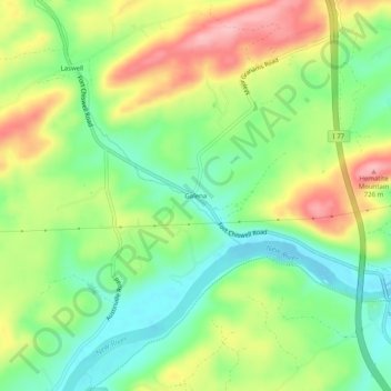
名前:Galenaの地形図、標高、地勢。
場所:Galena, Wythe County, Virginia, 24360, United States (36.86123 -80.91313 36.90123 -80.87313)
平均標高:642 m
最低標高:582 m
最大標高:725 m
寄付をします
次の冒険に備えよう:
Amazonアソシエイトとして、このサイトは対象となる購入から手数料を受け取りますが、お客様の負担はありません。
その他の地形図
地図をクリックすると、その地形、その標高、その地勢が表示されます。
Wytheville
United States > Virginia > Wythe County
Wytheville is nestled within the scenic Appalachian Mountains, characterized by a varied topography that features rolling hills, gentle valleys, and steep ridges. The town sits at an elevation of approximately 2,300 feet, which contributes to its cooler climate and offers picturesque views of the surrounding…
平均標高:720 m
寄付をします
次の冒険に備えよう:
Amazonアソシエイトとして、このサイトは対象となる購入から手数料を受け取りますが、お客様の負担はありません。
Wytheville
United States > Virginia > Wythe County
Due to its elevation, the climate of Wytheville is either classified as mountain temperate or humid subtropical (Köppen Cfb or Cfa, respectively), and the town straddles the border between USDA Plant Hardiness Zones 6B and 7A. Summers are warm and humid, although significantly cooler than low-elevation places…
平均標高:720 m