
寄付をします
次の冒険に備えよう:
Amazonアソシエイトとして、このサイトは対象となる購入から手数料を受け取りますが、お客様の負担はありません。
Zitácuaro地形図
地図をクリックすると標高が表示されます。
寄付をします
次の冒険に備えよう:
Amazonアソシエイトとして、このサイトは対象となる購入から手数料を受け取りますが、お客様の負担はありません。
Zitácuaro
Zitácuaro stands at 19°26′N 100°22′W / 19.433°N 100.367°W / 19.433; -100.367, in the northeast corner of Michoacán, some 150 km east of state capital Morelia, at an elevation of 1,942 metres above sea level. The municipality covers a total of 498 km2 and is drained by the Río Zitácuaro, the Río San Andrés, and the Río San Juan Viejo. The surrounding terrain are avocado orchards and the pine-covered mountains of the Sierra Madre Occidental; to the north of Zitácuaro are the famed Mexican wintering grounds of the monarch butterfly.
寄付をします
次の冒険に備えよう:
Amazonアソシエイトとして、このサイトは対象となる購入から手数料を受け取りますが、お客様の負担はありません。
この地図について
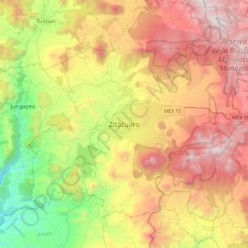
名前:Zitácuaroの地形図、標高、地勢。
場所:Zitácuaro, Michoacán, 61506, Mexico (19.27440 -100.51531 19.59440 -100.19531)
平均標高:2,157 m
最低標高:905 m
最大標高:3,624 m
寄付をします
次の冒険に備えよう:
Amazonアソシエイトとして、このサイトは対象となる購入から手数料を受け取りますが、お客様の負担はありません。