
寄付をします
次の冒険に備えよう:
Amazonアソシエイトとして、このサイトは対象となる購入から手数料を受け取りますが、お客様の負担はありません。
Sandyford地形図
地図をクリックすると標高が表示されます。
寄付をします
次の冒険に備えよう:
Amazonアソシエイトとして、このサイトは対象となる購入から手数料を受け取りますが、お客様の負担はありません。
この地図について
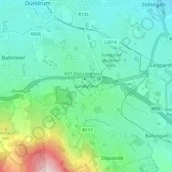
名前:Sandyfordの地形図、標高、地勢。
平均標高:121 m
最低標高:42 m
最大標高:404 m
寄付をします
次の冒険に備えよう:
Amazonアソシエイトとして、このサイトは対象となる購入から手数料を受け取りますが、お客様の負担はありません。
その他の地形図
地図をクリックすると、その地形、その標高、その地勢が表示されます。
寄付をします
次の冒険に備えよう:
Amazonアソシエイトとして、このサイトは対象となる購入から手数料を受け取りますが、お客様の負担はありません。
寄付をします
次の冒険に備えよう:
Amazonアソシエイトとして、このサイトは対象となる購入から手数料を受け取りますが、お客様の負担はありません。
Swords
At the northern end of the street stands Swords Castle, 200m northeast of the ecclesiastical site, which was built in the early 13th century. A short distance north of the castle is the elevation known as Spittal Hill, where a hospital once stood.
平均標高:25 m
寄付をします
次の冒険に備えよう:
Amazonアソシエイトとして、このサイトは対象となる購入から手数料を受け取りますが、お客様の負担はありません。
寄付をします
次の冒険に備えよう:
Amazonアソシエイトとして、このサイトは対象となる購入から手数料を受け取りますが、お客様の負担はありません。
Baldoyle
Ireland > County Dublin > Sutton
A description of Baldoyle from Lewis's Topographical Dictionary of Ireland (Dublin, 1837) gives a useful summary of what was then a substantial rural fishing village.
平均標高:2 m
寄付をします
次の冒険に備えよう:
Amazonアソシエイトとして、このサイトは対象となる購入から手数料を受け取りますが、お客様の負担はありません。
Lambay Island
Lambay Island is the largest island off the east coast of Ireland. It covers about 2.5 km2 (0.97 sq mi). The highest point – a hill known as Knockbane – rises to 126 m (413 ft). The island's high ground lies to the east and aside from Knockbane includes Heath Hill and Tinian Hill, and in the extreme…
平均標高:14 m
寄付をします
次の冒険に備えよう:
Amazonアソシエイトとして、このサイトは対象となる購入から手数料を受け取りますが、お客様の負担はありません。
寄付をします
次の冒険に備えよう:
Amazonアソシエイトとして、このサイトは対象となる購入から手数料を受け取りますが、お客様の負担はありません。
寄付をします
次の冒険に備えよう:
Amazonアソシエイトとして、このサイトは対象となる購入から手数料を受け取りますが、お客様の負担はありません。
寄付をします
次の冒険に備えよう:
Amazonアソシエイトとして、このサイトは対象となる購入から手数料を受け取りますが、お客様の負担はありません。
Drimnagh Castle
Ireland > County Dublin > Dublin
By the mid-19th century, the castle was owned by the then Marquess of Lansdowne, with Samuel Lewis's Topographical Dictionary of Ireland (printed 1837) stating that it was an "irregular pile", the "property of the Marquess of Lansdowne [..] occupied by Mr. E. Cavanagh".
平均標高:45 m
寄付をします
次の冒険に備えよう:
Amazonアソシエイトとして、このサイトは対象となる購入から手数料を受け取りますが、お客様の負担はありません。
寄付をします
次の冒険に備えよう:
Amazonアソシエイトとして、このサイトは対象となる購入から手数料を受け取りますが、お客様の負担はありません。
寄付をします
次の冒険に備えよう:
Amazonアソシエイトとして、このサイトは対象となる購入から手数料を受け取りますが、お客様の負担はありません。
寄付をします
次の冒険に備えよう:
Amazonアソシエイトとして、このサイトは対象となる購入から手数料を受け取りますが、お客様の負担はありません。
Swords
At the northern end of the street stands Swords Castle, 200m northeast of the ecclesiastical site, which was built in the early 13th century. A short distance north of the castle is the elevation known as Spittal Hill, where a hospital once stood.
平均標高:25 m
寄付をします
次の冒険に備えよう:
Amazonアソシエイトとして、このサイトは対象となる購入から手数料を受け取りますが、お客様の負担はありません。
寄付をします
次の冒険に備えよう:
Amazonアソシエイトとして、このサイトは対象となる購入から手数料を受け取りますが、お客様の負担はありません。
Drimnagh Castle
Ireland > County Dublin > Dublin
By the mid-19th century, the castle was owned by the then Marquess of Lansdowne, with Samuel Lewis's Topographical Dictionary of Ireland (printed 1837) stating that it was an "irregular pile", the "property of the Marquess of Lansdowne [..] occupied by Mr. E. Cavanagh".
平均標高:45 m
寄付をします
次の冒険に備えよう:
Amazonアソシエイトとして、このサイトは対象となる購入から手数料を受け取りますが、お客様の負担はありません。
寄付をします
次の冒険に備えよう:
Amazonアソシエイトとして、このサイトは対象となる購入から手数料を受け取りますが、お客様の負担はありません。
寄付をします
次の冒険に備えよう:
Amazonアソシエイトとして、このサイトは対象となる購入から手数料を受け取りますが、お客様の負担はありません。
Swords
At the northern end of the street stands Swords Castle, 200m northeast of the ecclesiastical site, which was built in the early 13th century. A short distance north of the castle is the elevation known as Spittal Hill, where a hospital once stood.
平均標高:25 m
寄付をします
次の冒険に備えよう:
Amazonアソシエイトとして、このサイトは対象となる購入から手数料を受け取りますが、お客様の負担はありません。
寄付をします
次の冒険に備えよう:
Amazonアソシエイトとして、このサイトは対象となる購入から手数料を受け取りますが、お客様の負担はありません。
寄付をします
次の冒険に備えよう:
Amazonアソシエイトとして、このサイトは対象となる購入から手数料を受け取りますが、お客様の負担はありません。
寄付をします
次の冒険に備えよう:
Amazonアソシエイトとして、このサイトは対象となる購入から手数料を受け取りますが、お客様の負担はありません。
Swords
At the northern end of the street stands Swords Castle, 200m northeast of the ecclesiastical site, which was built in the early 13th century. A short distance north of the castle is the elevation known as Spittal Hill, where a hospital once stood.
平均標高:24 m
寄付をします
次の冒険に備えよう:
Amazonアソシエイトとして、このサイトは対象となる購入から手数料を受け取りますが、お客様の負担はありません。