
寄付をします
次の冒険に備えよう:
Amazonアソシエイトとして、このサイトは対象となる購入から手数料を受け取りますが、お客様の負担はありません。
Sackertown地形図
地図をクリックすると標高が表示されます。
寄付をします
次の冒険に備えよう:
Amazonアソシエイトとして、このサイトは対象となる購入から手数料を受け取りますが、お客様の負担はありません。
この地図について
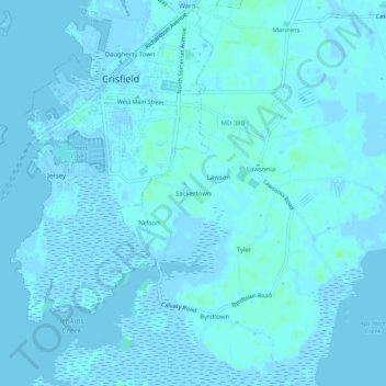
名前:Sackertownの地形図、標高、地勢。
場所:Sackertown, Somerset County, Maryland, 21817, United States (37.95235 -75.86271 37.99235 -75.82271)
平均標高:1 m
最低標高:-4 m
最大標高:6 m
寄付をします
次の冒険に備えよう:
Amazonアソシエイトとして、このサイトは対象となる購入から手数料を受け取りますが、お客様の負担はありません。
その他の地形図
地図をクリックすると、その地形、その標高、その地勢が表示されます。
Crisfield
United States > Maryland > Somerset County
Crisfield is a very compact city, with little vacant land. According to the United States Census Bureau, the city has a total area of 3.06 square miles (7.93 km2), of which 1.62 square miles (4.20 km2) (53.0%) is land and 1.44 square miles (3.73 km2) (47.0%) is water. As one of the southern points on the…
平均標高:1 m
寄付をします
次の冒険に備えよう:
Amazonアソシエイトとして、このサイトは対象となる購入から手数料を受け取りますが、お客様の負担はありません。