
寄付をします
次の冒険に備えよう:
Amazonアソシエイトとして、このサイトは対象となる購入から手数料を受け取りますが、お客様の負担はありません。
La Misión地形図
地図をクリックすると標高が表示されます。
寄付をします
次の冒険に備えよう:
Amazonアソシエイトとして、このサイトは対象となる購入から手数料を受け取りますが、お客様の負担はありません。
この地図について
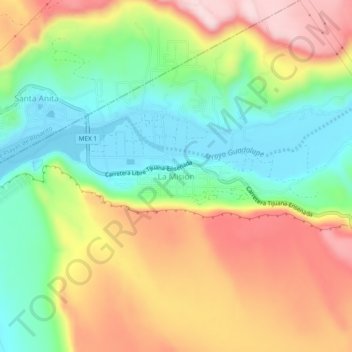
名前:La Misiónの地形図、標高、地勢。
平均標高:136 m
最低標高:2 m
最大標高:308 m
寄付をします
次の冒険に備えよう:
Amazonアソシエイトとして、このサイトは対象となる購入から手数料を受け取りますが、お客様の負担はありません。
その他の地形図
地図をクリックすると、その地形、その標高、その地勢が表示されます。
Parque Nacional Sierra de San Pedro Mártir
Mexico > Baja California > Municipio de Ensenada
Sierra de San Pedro Mártir National Park was officially created by decree on April 26, 1947, in which 72,909 hectares were set aside and declared protected by the Mexican Federal government. The National Astronomical Observatory is located at an elevation of 2,830 m (9,280 ft). The observatory was built in…
平均標高:1,463 m
寄付をします
次の冒険に備えよう:
Amazonアソシエイトとして、このサイトは対象となる購入から手数料を受け取りますが、お客様の負担はありません。
Isla Guadalupe
Mexico > Baja California > Municipio de Ensenada
Campo Pista is located at the small airport, near the center of the island (29°01′24.04″N 118°16′21.75″W / 29.0233444°N 118.2727083°W / 29.0233444; -118.2727083, elevation:592 m, direction:05/23).[1] Airport Isla Guadalupe (ICAO Code MMGD) has a 1,200-metre-long (3,900 ft) runway. At the…
平均標高:113 m
Ejido El Porvenir
Mexico > Baja California > Municipio de Ensenada
The valley slopes gently from northeast to southwest with an average elevation of 344 metres (1,129 ft) above sea level. The margins of the plain are composed of alluvial fans and colluvium of reddish soil from the surrounding hillsides. Chaparral grows along the rocky slopes and live oak trees can be found in…
平均標高:317 m