
寄付をします
次の冒険に備えよう:
Amazonアソシエイトとして、このサイトは対象となる購入から手数料を受け取りますが、お客様の負担はありません。
Sangeang Api地形図
地図をクリックすると標高が表示されます。
寄付をします
次の冒険に備えよう:
Amazonアソシエイトとして、このサイトは対象となる購入から手数料を受け取りますが、お客様の負担はありません。
Sangeang Api
Since mid-June 2013, authorities had put the volcano on 'high alert' for a possible eruption. On May 30, 2014, a major eruption occurred at around 3:55 p.m. local time. Farmers working on the island were evacuated. Ash and smoke quickly rose to an altitude of 15–20 km (≈10–16 miles) into the sky. By the next morning, the ash cloud had crossed the northwest coast of Australia in the Kimberley region, and airlines had cancelled flights into and from Darwin, Northern Territory. It later went as far as Alice Springs in the Northern Territory. On 31 May some flights from Melbourne and Adelaide to Bali were also cancelled.
寄付をします
次の冒険に備えよう:
Amazonアソシエイトとして、このサイトは対象となる購入から手数料を受け取りますが、お客様の負担はありません。
この地図について
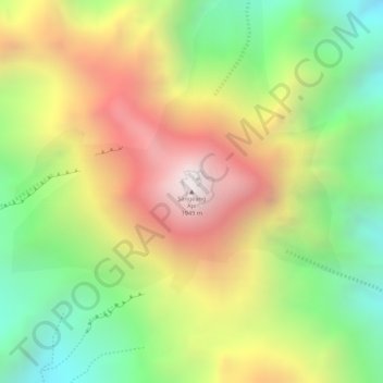
名前:Sangeang Apiの地形図、標高、地勢。
平均標高:1,382 m
最低標高:864 m
最大標高:1,922 m
寄付をします
次の冒険に備えよう:
Amazonアソシエイトとして、このサイトは対象となる購入から手数料を受け取りますが、お客様の負担はありません。