
このサイトをサポートしていただきありがとうございます ❤️
寄付をします
寄付をします
次の冒険に備えよう:
Amazonアソシエイトとして、このサイトは対象となる購入から手数料を受け取りますが、お客様の負担はありません。
Amatikulu地形図
地図をクリックすると標高が表示されます。
このサイトをサポートしていただきありがとうございます ❤️
寄付をします
寄付をします
次の冒険に備えよう:
Amazonアソシエイトとして、このサイトは対象となる購入から手数料を受け取りますが、お客様の負担はありません。
この地図について
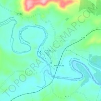
名前:Amatikuluの地形図、標高、地勢。
平均標高:54 m
最低標高:14 m
最大標高:192 m
このサイトをサポートしていただきありがとうございます ❤️
寄付をします
寄付をします
次の冒険に備えよう:
Amazonアソシエイトとして、このサイトは対象となる購入から手数料を受け取りますが、お客様の負担はありません。
その他の地形図
地図をクリックすると、その地形、その標高、その地勢が表示されます。
uThukela
South Africa > KwaZulu-Natal > King Cetswayo District Municipality > uMlalazi Local Municipality
The river originates in Mont-aux-Sources of the Drakensberg Mountains at an elevation of almost 11,000 feet and plunges 947 metres down the Tugela Falls. The Mont-aux-Sources is also the origin of tributaries of two other major South African rivers, the Orange and the Caledon River. From the Drakensberg range,…
平均標高:238 m