
寄付をします
次の冒険に備えよう:
Amazonアソシエイトとして、このサイトは対象となる購入から手数料を受け取りますが、お客様の負担はありません。
Loreto地形図
地図をクリックすると標高が表示されます。
寄付をします
次の冒険に備えよう:
Amazonアソシエイトとして、このサイトは対象となる購入から手数料を受け取りますが、お客様の負担はありません。
Loreto
Loreto is located on the east coast of the Baja California Peninsula, at 26º00'46" N 111º20'36" W. It is bordered on the east by the Gulf of California, on the west by the Transpeninsular Highway, and on the south by the Arroyo Loreto, a dry creek bed that only fills with water after a heavy rainfall. The city is built on relatively flat land with an average elevation is 10 meters (33 ft) above sea level. "La Giganta" Mountain Range ("Sierra de la Giganta") lies to the west, extending along the center of the state of Baja California Sur, parallel to the gulf coast.
寄付をします
次の冒険に備えよう:
Amazonアソシエイトとして、このサイトは対象となる購入から手数料を受け取りますが、お客様の負担はありません。
この地図について
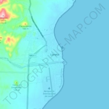
名前:Loretoの地形図、標高、地勢。
平均標高:22 m
最低標高:-1 m
最大標高:313 m
寄付をします
次の冒険に備えよう:
Amazonアソシエイトとして、このサイトは対象となる購入から手数料を受け取りますが、お客様の負担はありません。
その他の地形図
地図をクリックすると、その地形、その標高、その地勢が表示されます。