
寄付をします
次の冒険に備えよう:
Amazonアソシエイトとして、このサイトは対象となる購入から手数料を受け取りますが、お客様の負担はありません。
Jawbone地形図
地図をクリックすると標高が表示されます。
寄付をします
次の冒険に備えよう:
Amazonアソシエイトとして、このサイトは対象となる購入から手数料を受け取りますが、お客様の負担はありません。
この地図について
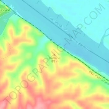
名前:Jawboneの地形図、標高、地勢。
場所:Jawbone, Sainte Genevieve County, Missouri, United States (38.07334 -90.19517 38.07344 -90.19507)
平均標高:146 m
最低標高:107 m
最大標高:206 m
寄付をします
次の冒険に備えよう:
Amazonアソシエイトとして、このサイトは対象となる購入から手数料を受け取りますが、お客様の負担はありません。
その他の地形図
地図をクリックすると、その地形、その標高、その地勢が表示されます。
Saint Louis County
The foothills of the Ozark Mountains begin in southwestern St. Louis County, with most of the rest of the county being a fairly level plateau. This western part of the county is the least developed, due to rugged topography. Bluffs along the Mississippi in the south of the county rise about 200–300 feet…
平均標高:166 m
寄付をします
次の冒険に備えよう:
Amazonアソシエイトとして、このサイトは対象となる購入から手数料を受け取りますが、お客様の負担はありません。
Lake Of The Ozarks
United States > Missouri > Camden County > Osage Beach
The lake was created by the construction of the 2,543-foot-long (775 m) Bagnell Dam by the Union Electric Company of St. Louis, Missouri. The principal engineering firm was Stone and Webster. Construction began August 8, 1929, and was completed in April 1931; the lake reached spillway elevation on May 20,…
平均標高:265 m
寄付をします
次の冒険に備えよう:
Amazonアソシエイトとして、このサイトは対象となる購入から手数料を受け取りますが、お客様の負担はありません。
寄付をします
次の冒険に備えよう:
Amazonアソシエイトとして、このサイトは対象となる購入から手数料を受け取りますが、お客様の負担はありません。
寄付をします
次の冒険に備えよう:
Amazonアソシエイトとして、このサイトは対象となる購入から手数料を受け取りますが、お客様の負担はありません。
寄付をします
次の冒険に備えよう:
Amazonアソシエイトとして、このサイトは対象となる購入から手数料を受け取りますが、お客様の負担はありません。
寄付をします
次の冒険に備えよう:
Amazonアソシエイトとして、このサイトは対象となる購入から手数料を受け取りますが、お客様の負担はありません。
寄付をします
次の冒険に備えよう:
Amazonアソシエイトとして、このサイトは対象となる購入から手数料を受け取りますが、お客様の負担はありません。
寄付をします
次の冒険に備えよう:
Amazonアソシエイトとして、このサイトは対象となる購入から手数料を受け取りますが、お客様の負担はありません。
寄付をします
次の冒険に備えよう:
Amazonアソシエイトとして、このサイトは対象となる購入から手数料を受け取りますが、お客様の負担はありません。
寄付をします
次の冒険に備えよう:
Amazonアソシエイトとして、このサイトは対象となる購入から手数料を受け取りますが、お客様の負担はありません。
St. Joseph
United States > Missouri > Buchanan County
Under the Köppen climate classification, St. Joseph has a humid subtropical climate (Cfa) bordering on a humid continental climate (Dfa), although under United States isotherms of 32 °F (0 °C) the station is firmly continental. The monthly weather averages listed below are taken from National Weather…
平均標高:277 m
寄付をします
次の冒険に備えよう:
Amazonアソシエイトとして、このサイトは対象となる購入から手数料を受け取りますが、お客様の負担はありません。
寄付をします
次の冒険に備えよう:
Amazonアソシエイトとして、このサイトは対象となる購入から手数料を受け取りますが、お客様の負担はありません。