
寄付をします
次の冒険に備えよう:
Amazonアソシエイトとして、このサイトは対象となる購入から手数料を受け取りますが、お客様の負担はありません。
Yellow Sulphur地形図
地図をクリックすると標高が表示されます。
寄付をします
次の冒険に備えよう:
Amazonアソシエイトとして、このサイトは対象となる購入から手数料を受け取りますが、お客様の負担はありません。
この地図について
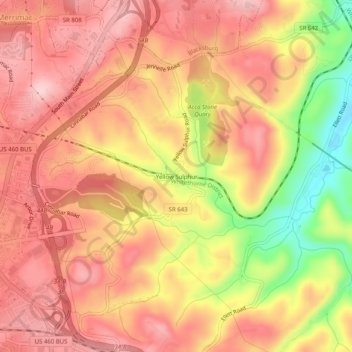
名前:Yellow Sulphurの地形図、標高、地勢。
平均標高:594 m
最低標高:453 m
最大標高:669 m
寄付をします
次の冒険に備えよう:
Amazonアソシエイトとして、このサイトは対象となる購入から手数料を受け取りますが、お客様の負担はありません。
その他の地形図
地図をクリックすると、その地形、その標高、その地勢が表示されます。
Blacksburg
United States > Virginia > Montgomery County
Blacksburg exhibits a varied topography characterized by its rolling hills and elevation changes. The town is situated at an average elevation of approximately 2,040 feet (621 meters) above sea level, with elevations ranging from about 1,440 feet (440 meters) to peaks reaching approximately 2,800 feet (860…
平均標高:621 m
Blacksburg
United States > Virginia > Montgomery County
In the mid-1600s, English colonists were still uncertain of what lay beyond the Allegheny Mountains, whose topography and possession by native inhabitants, Tutelo-speaking tribes, were a barrier to expanded settlement by the Colony of Virginia. Abraham Wood, who commanded Fort Henry on the frontier (now the…
平均標高:621 m
寄付をします
次の冒険に備えよう:
Amazonアソシエイトとして、このサイトは対象となる購入から手数料を受け取りますが、お客様の負担はありません。
寄付をします
次の冒険に備えよう:
Amazonアソシエイトとして、このサイトは対象となる購入から手数料を受け取りますが、お客様の負担はありません。
Blacksburg
United States > Virginia > Montgomery County
In the mid-1600s, English colonists were still uncertain of what lay beyond the Allegheny Mountains, whose topography and possession by native inhabitants, Tutelo-speaking tribes, were a barrier to expanded settlement by the Colony of Virginia. Abraham Wood, who commanded Fort Henry on the frontier (now the…
平均標高:621 m
寄付をします
次の冒険に備えよう:
Amazonアソシエイトとして、このサイトは対象となる購入から手数料を受け取りますが、お客様の負担はありません。