
このサイトをサポートしていただきありがとうございます ❤️
寄付をします
寄付をします
次の冒険に備えよう:
Amazonアソシエイトとして、このサイトは対象となる購入から手数料を受け取りますが、お客様の負担はありません。
Kanlaon地形図
地図をクリックすると標高が表示されます。
このサイトをサポートしていただきありがとうございます ❤️
寄付をします
寄付をします
次の冒険に備えよう:
Amazonアソシエイトとして、このサイトは対象となる購入から手数料を受け取りますが、お客様の負担はありません。
Kanlaon
Kanlaon, also known as Mount Kanlaon and Kanlaon Volcano (Hiligaynon: Bolkang Kanglaon; Cebuano: Bolkang Kanglaon; Filipino: Bulkang Kanlaon), is an active andesitic stratovolcano and the highest mountain on the island of Negros in the Philippines, as well as the highest peak in the Visayas, with an elevation of 2,465 m (8,087 ft) above sea level. Mount Kanlaon ranks as the 42nd-highest peak of an island in the world.
このサイトをサポートしていただきありがとうございます ❤️
寄付をします
寄付をします
次の冒険に備えよう:
Amazonアソシエイトとして、このサイトは対象となる購入から手数料を受け取りますが、お客様の負担はありません。
この地図について
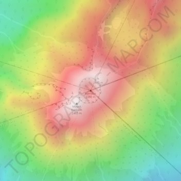
名前:Kanlaonの地形図、標高、地勢。
平均標高:1,959 m
最低標高:1,391 m
最大標高:2,430 m
このサイトをサポートしていただきありがとうございます ❤️
寄付をします
寄付をします
次の冒険に備えよう:
Amazonアソシエイトとして、このサイトは対象となる購入から手数料を受け取りますが、お客様の負担はありません。