
Caloundra地形図
地図をクリックすると標高が表示されます。
Caloundra
Caloundra, located on Queensland's Sunshine Coast, features a diverse coastal topography characterized by sandy beaches, rocky headlands, and nearby elevated terrains. The suburb of Kings Beach exemplifies this diversity, with its sandy shoreline to the south and southeast, and a rocky headland rising to about 20 meters (66 feet) to the north and northeast. The area is generally hilly, with elevations reaching over 40 meters (131 feet) in certain parts. To the west, the Mooloolah River flows eastward across Glenview towards the coast, with nearby elevations such as Meridan Hill at 140 meters (459 feet) and Mount Sippy at 180 meters (591 feet). Further southwest, Mount Mellum rises to 406 meters (1,332 feet), adding to the region's varied terrain. Additionally, the Pumicestone Passage, a narrow waterway between Bribie Island and the mainland, extends from Caloundra southward for about 35 kilometers (22 miles), contributing to the area's intricate coastal landscape.
この地図について
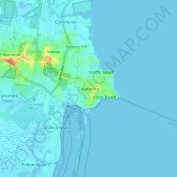
名前:Caloundraの地形図、標高、地勢。
場所:Caloundra, Queensland, 4551, Australia (-26.83816 153.09544 -26.75816 153.17544)
平均標高:5 m
最低標高:-4 m
最大標高:73 m
その他の地形図
地図をクリックすると、その地形、その標高、その地勢が表示されます。
City of Brisbane
Brisbane's topography is characterized by a series of hills and ranges that define its landscape. The city is situated on a low-lying floodplain, with the Brisbane River meandering through its heart, creating a winding course with many steep curves from the southwest to its mouth at Moreton Bay in the east.…
平均標高:71 m
Sunshine Coast Regional
The Sunshine Coast Regional area in Queensland, Australia, features a diverse topography that ranges from coastal plains to rugged hinterlands. Along the coastline, the terrain is predominantly flat, with average elevations around 20 meters (66 feet) above sea level. Inland, the landscape transitions to…
平均標高:56 m
Brisbane River
The RAAF also perform a practice session in the days preceding the event, serving as an opportunity to both practice beforehand and also promote Riverfire. One of the most popular RAAF aircraft to perform at Riverfire was the F-111 which was known for performing a 'dump-and-burn' above the city. The final…
平均標高:235 m
Gatton
The area has a humid subtropical climate, with hot, humid summers and mild, sunny winters, albeit with cool nights. Heavy summer rain and warm conditions have provided ideal conditions for the areas agricultural productivity, although droughts and heatwaves can be problematic at times. Temperatures in Gatton…
平均標高:118 m
Barron River
Australia > Queensland > Kowrowa
The Barron's headwaters start in the Mount Hypipamee National Park near Mount Hypipamee at an elevation of 1,200 metres (3,900 ft). The river then flows north 65 kilometres (40 mi) across the Atherton Tablelands before finally turning east after Mareeba towards Kuranda. After passing under the Kuranda Range…
平均標高:360 m
Highvale
The area is the headwaters of the South Pine River. In the north and west of the locality the elevation rises to heights greater than 500 m above sea level along the D'Aguilar Range. Highvale is positioned at the base of Mount Nebo and Mount Glorious.
平均標高:251 m