
寄付をします
次の冒険に備えよう:
Amazonアソシエイトとして、このサイトは対象となる購入から手数料を受け取りますが、お客様の負担はありません。
Talima地形図
地図をクリックすると標高が表示されます。
寄付をします
次の冒険に備えよう:
Amazonアソシエイトとして、このサイトは対象となる購入から手数料を受け取りますが、お客様の負担はありません。
この地図について
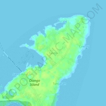
名前:Talimaの地形図、標高、地勢。
場所:Talima, Lapu-Lapu, Central Visayas, 6015, Philippines (10.25418 124.03979 10.29418 124.07979)
平均標高:3 m
最低標高:-2 m
最大標高:12 m
寄付をします
次の冒険に備えよう:
Amazonアソシエイトとして、このサイトは対象となる購入から手数料を受け取りますが、お客様の負担はありません。
その他の地形図
地図をクリックすると、その地形、その標高、その地勢が表示されます。
寄付をします
次の冒険に備えよう:
Amazonアソシエイトとして、このサイトは対象となる購入から手数料を受け取りますが、お客様の負担はありません。
Olango Island
Philippines > Lapu-Lapu > Tingo
The Olango group of islands is an island group composed of the island of Olango and six satellite islets. The six neighboring islets are Sulpa, Gilutongan (also spelled Hilutangan), Nalusuan, Caohagan, Pangan-an, and Camungi. These are bound by continuous fringing reefs (steep reef wall on the west and sloping…
平均標高:2 m