
イングランド地形図
インタラクティブマップ
地図をクリックすると標高が表示されます。
この地図について
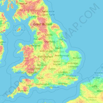
名前:イングランドの地形図、標高、地勢。
場所:イングランド, イギリス (49.67400 -6.70475 55.91700 2.09191)
平均標高:55 m
最低標高:-3 m
最大標高:966 m
地形は変化に富む。ただし全体的には平坦な地形であり、最高峰のスコーフェル山でも978mと、イングランドには標高1000mを超える地点はない。北部と西部は全般に丸みを帯びた山岳地帯で、ペナイン山脈がイングランド北部の背骨を形成している。北西部カンブリアにはカンブリア山地があり、ここは大小様々な湖が連なる湖水地方として知られ、ピーターラビットの舞台としても有名である。フェンと呼ばれる東部の湿地帯は農業用地になっている。森林が占める割合は低く、小規模な森が各地に点在する程度である。
その他の地形図
地図をクリックすると、その地形、その標高、その地勢が表示されます。
グリムズビー (イングランド)
イギリス > イングランド > North East Lincolnshire
グリムズビー (イングランド), North East Lincolnshire, イングランド, DN31 1NR, イギリス
平均標高:6 m
Kendal
イギリス > イングランド > Westmorland and Furness
Kendal, Westmorland and Furness, イングランド, イギリス
平均標高:112 m
Lower Grove
イギリス > イングランド > Essex > Maldon
Lower Grove, Tolleshunt D'Arcy, Maldon, Essex, イングランド, イギリス
平均標高:14 m
New Romney
イギリス > イングランド > ケント > Folkestone and Hythe
New Romney, Folkestone and Hythe, ケント, イングランド, イギリス
平均標高:2 m
Hessle
イギリス > イングランド > East Riding of Yorkshire
Hessle, East Riding of Yorkshire, イングランド, イギリス
平均標高:10 m
Burton-on-Trent
イギリス > イングランド > Staffordshire > East Staffordshire
Burton-on-Trent, East Staffordshire, Staffordshire, イングランド, DE14 1JN, イギリス
平均標高:69 m
Heronsgate
イギリス > イングランド > Hertfordshire > Three Rivers
Heronsgate, Three Rivers, Hertfordshire, イングランド, WD3 5DE, イギリス
平均標高:92 m
Clewer Village
イギリス > イングランド > Windsor and Maidenhead
Clewer Village, Windsor and Maidenhead, イングランド, SL4 5JG, イギリス
平均標高:26 m
Old Harry Rocks
Old Harry Rocks, Studland, Dorset, South West England, イングランド, BH19 3AN, イギリス
平均標高:7 m
Holy Island
Holy Island, Trearddur, Ynys Môn / Isle of Anglesey, ウェールズ, イギリス
平均標高:9 m