
ウェールズ地形図
インタラクティブマップ
地図をクリックすると標高が表示されます。
この地図について
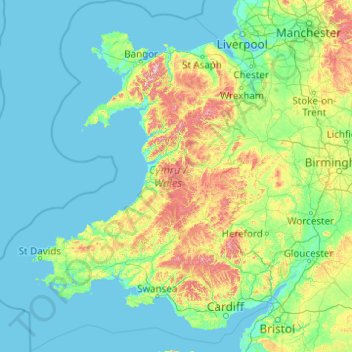
名前:ウェールズの地形図、標高、地勢。
場所:ウェールズ, イギリス (51.22903 -5.80773 53.63500 -2.64986)
平均標高:99 m
最低標高:0 m
最大標高:1,001 m
ウェールズはロンドンの西方およそ200kmに位置し、アイルランドと海を隔て、リヴァプール湾、カーデガン湾、ブリストル海峡に囲まれる。国土の大部分は山地で、南北にカンブリア山脈が走る。その名前はウェールズの古名で、地質時代の古生代カンブリア紀にも名づけられた。さらに、この地域を調査した地質学者が部族名からオルドビス紀とシルル紀も命名した。北のスノードニア国立公園には最高峰スノードン山(標高1085m)がそびえる。国立公園であるスノードニア、ブレコンビーコン、ペンブルッククシャー海岸があるゴワー半島、ペンブルックシャー海岸等のあるカーデガン湾は風光明媚で遺産海岸に指定されているが、大西洋に面する海岸は数多くの難破船を出している。主な都市はカーディフ、スウォンジ、レクサム、ニューポートなどである。
その他の地形図
地図をクリックすると、その地形、その標高、その地勢が表示されます。
グリムズビー (イングランド)
イギリス > イングランド > North East Lincolnshire
グリムズビー (イングランド), North East Lincolnshire, イングランド, DN31 1NR, イギリス
平均標高:6 m
Kendal
イギリス > イングランド > Westmorland and Furness
Kendal, Westmorland and Furness, イングランド, イギリス
平均標高:112 m
Lower Grove
イギリス > イングランド > Essex > Maldon
Lower Grove, Tolleshunt D'Arcy, Maldon, Essex, イングランド, イギリス
平均標高:14 m
New Romney
イギリス > イングランド > ケント > Folkestone and Hythe
New Romney, Folkestone and Hythe, ケント, イングランド, イギリス
平均標高:2 m
Hessle
イギリス > イングランド > East Riding of Yorkshire
Hessle, East Riding of Yorkshire, イングランド, イギリス
平均標高:10 m
Burton-on-Trent
イギリス > イングランド > Staffordshire > East Staffordshire
Burton-on-Trent, East Staffordshire, Staffordshire, イングランド, DE14 1JN, イギリス
平均標高:69 m
Heronsgate
イギリス > イングランド > Hertfordshire > Three Rivers
Heronsgate, Three Rivers, Hertfordshire, イングランド, WD3 5DE, イギリス
平均標高:92 m
Clewer Village
イギリス > イングランド > Windsor and Maidenhead
Clewer Village, Windsor and Maidenhead, イングランド, SL4 5JG, イギリス
平均標高:26 m
Old Harry Rocks
Old Harry Rocks, Studland, Dorset, South West England, イングランド, BH19 3AN, イギリス
平均標高:7 m
Holy Island
Holy Island, Trearddur, Ynys Môn / Isle of Anglesey, ウェールズ, イギリス
平均標高:9 m